| Uri Alps | |
|---|---|
 The Dammastock from the Göscheneralp | |
| Highest point | |
| Peak | Dammastock |
| Elevation | 3,630 m (11,910 ft) |
| Coordinates | 46°38′28″N 8°25′6″E / 46.64111°N 8.41833°E |
| Naming | |
| Native name | Urner Alpen (German) |
| Geography | |
| Country | Switzerland |
| Cantons | Bern, Obwalden, Valais, Uri and Nidwalden |
| Parent range | Western Alps |
| Borders on | Bernese Alps, Emmental Alps, Schwyzer Alps, Glarus Alps and Lepontine Alps |
| Topo map | Swiss Federal Office of Topography swisstopo |
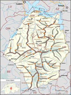
The Uri Alps (also known as Urner Alps, German: Urner Alpen) are a mountain range in Central Switzerland and part of the Western Alps. They extend into the cantons of Obwalden, Valais, Bern, Uri and Nidwalden and are bordered by the Bernese Alps (Grimsel Pass) and the Emmental Alps to the west (the four lakes: Lungerersee, Sarnersee, Wichelsee, and Alpnachersee), the Schwyzer Alps to the north (Lake Lucerne), the Lepontine Alps to the south (the valley of Urseren with Andermatt) and the Glarus Alps to the east (Reuss).
The Uri Alps are composed of two distinct groups separated by the Susten Pass. The Dammastock massif on the south is the most glaciated part while the northern part, which culminates on Titlis, has lower summits but greater extent.
