| Baker River | |
|---|---|
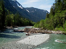
 Baker River upstream of Baker Lake | |
| Location | |
| Country | United States |
| State | Washington |
| County | Skagit, Whatcom |
| Physical characteristics | |
| Source | Cascade Range |
| • location | Whatcom Peak, Whatcom County |
| • coordinates | 48°51′1″N 121°22′52″W / 48.85028°N 121.38111°W[1] |
| • elevation | 5,800 ft (1,800 m)[2] |
| Mouth | Skagit River |
• location | Concrete, Skagit County |
• coordinates | 48°45′54″N 121°32′34″W / 48.76500°N 121.54278°W[1] |
• elevation | 160 ft (49 m)[3] |
| Length | 33 mi (53 km) |
| Basin size | 297 sq mi (770 km2)[4] |
| Discharge | |
| • location | river mile 0.7 near Concrete, WA |
| • average | 2,662 cu ft/s (75.4 m3/s)[4] |
| • minimum | 30 cu ft/s (0.85 m3/s)[4] |
| • maximum | 36,600 cu ft/s (1,040 m3/s)[4] |
The Baker River is a 33-mile (53 km) long river in Whatcom County and Skagit County, northwestern Washington. It flows southwest from its headwaters in North Cascades National Park through the Mount Baker–Snoqualmie National Forest to Concrete, where it joins the Skagit River. The Baker River watershed includes many high peaks of the North Cascades, including the stratovolcano Mount Baker, with which the river shares its name. Geologically, the course of the river has been heavily influenced by Ice Age glaciations and previous eruptions of Mount Baker. Parts of the river valley are underlain by 500 feet (150 m) of old lava and debris flows, while other sections flow over glacial deposits.
The Baker River was the site of an Upper Skagit village before entry of gold prospectors in the 1850s. Homesteaders arriving in the Skagit Valley discovered limestone deposits at the mouth of the river and founded settlements on either side of the Baker River at its confluence with the Skagit. These deposits were mined starting in the early 1900s and drove the settlement and naming of the town of Concrete, where large cement plants operated until the 1970s.
While the upper reaches of the river flow through wilderness, the lower part has two hydroelectric dams constructed in 1927 and 1959 and operated by Puget Sound Energy. Although the dams block natural fish migration, a fish trapping system has been in use since 1985 to transport salmon around the dams.
- ^ a b "Baker River". Geographic Names Information System. United States Geological Survey, United States Department of the Interior. 1992-12-30. Retrieved 2022-08-04.
- ^ Cite error: The named reference
USGS Mount Blumwas invoked but never defined (see the help page). - ^ Puget Sound Energy, p. 160.
- ^ a b c d Cite error: The named reference
NWISwas invoked but never defined (see the help page).
