| Ushbas Үшбас | |
|---|---|
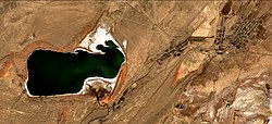
 Sentinel-2 image with the Ushbas flowing into lake Kyzylkol from the south | |
| Location | |
| Country | Kazakhstan |
| Physical characteristics | |
| Source | Karatau |
| • coordinates | 43°19′43″N 69°43′29″E / 43.32861°N 69.72472°E |
| Mouth | Kyzylkol |
• coordinates | 43°44′40″N 69°29′52″E / 43.74444°N 69.49778°E |
• elevation | 331 m (1,086 ft) |
| Length | 71 km (44 mi) |
| Basin size | 571 km2 (220 sq mi) |
| Discharge | |
| • average | 0.25 m3/s (8.8 cu ft/s) |
The Ushbas (Kazakh: Үшбас) is a river in southern Kazakhstan.[1][2] It has a length of 71 km (44 mi) and a drainage basin of 571 km2 (220 sq mi).[3][4]
The river flows across Sarysu district of the Zhambyl Region and Sozak District of the Turkistan Region. It has its mouth near Kumkent village.[1][4]
- ^ a b "L-41 Topographic Chart (in Russian)". Retrieved 9 September 2022.
- ^ "K-42 Topographic Chart (in Russian)". Retrieved 9 September 2022.
- ^ Cite error: The named reference
KЕwas invoked but never defined (see the help page). - ^ a b Google Earth
