This article needs additional citations for verification. (April 2011) |
Utrecht | |
|---|---|
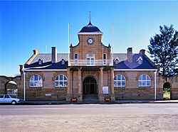
 Town Hall in Utrecht, KwaZulu-Natal. | |
| Coordinates: 27°39′36″S 30°19′48″E / 27.66000°S 30.33000°E | |
| Country | South Africa |
| Province | KwaZulu-Natal |
| District | Amajuba |
| Municipality | eMadlangeni |
| Established | 1853[1] |
| Area | |
| • Total | 57.76 km2 (22.30 sq mi) |
| Population (2022)[2] | |
| • Total | 5,290 |
| • Density | 92/km2 (240/sq mi) |
| Racial makeup (2022) | |
| • Black African | 41.3% |
| • Coloured | 6.9% |
| • Indian/Asian | 0.3% |
| • White | 50.5% |
| • Other | 1.1% |
| First languages (2022) | |
| • Zulu | 36.1% |
| • Afrikaans | 54.2% |
| • English | 15.2% |
| • Other | 4.5% |
| Time zone | UTC+2 (SAST) |
| Postal code (street) | 2980 |
| PO box | 2980 |
| Area code | 034 |
| Website | http://www.utrecht.co.za |
Utrecht is a town in the foothills of the Balele Mountains, in the northwestern corner of KwaZulu-Natal, South Africa. Newcastle, Kwazulu-Natal's third-largest urban centre, is 50 km from Utrecht. Utrecht has a population of approximately 32,000 (including surrounding areas).
The town is named after Utrecht, a Dutch city with the same name, as a result from Dutch settlers in the region.
Coal mining and cattle ranching are the predominant economic activities in Utrecht.
- ^ Robson, Linda Gillian (2011). "Annexure A" (PDF). The Royal Engineers and settlement planning in the Cape Colony 1806–1872: Approach, methodology and impact (PhD thesis). University of Pretoria. pp. xlv–lii. hdl:2263/26503.
- ^ a b c d "Main Place Utrecht". Census 2011.

