Vaala | |
|---|---|
Municipality | |
| Vaalan kunta Vaala kommun | |
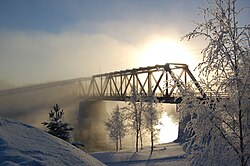
 Mist rising from Oulujoki river in Vaala | |
 Location of Vaala in Finland | |
| Coordinates: 64°33′N 026°50′E / 64.550°N 26.833°E | |
| Country | |
| Region | North Ostrobothnia |
| Sub-region | Oulunkaari |
| Charter | 1954 |
| Government | |
| • Municipality manager | Tytti Seppänen |
| Area (2018-01-01)[1] | |
| • Total | 1,764.04 km2 (681.10 sq mi) |
| • Land | 1,302.37 km2 (502.85 sq mi) |
| • Water | 461.45 km2 (178.17 sq mi) |
| • Rank | 54th largest in Finland |
| Population (2024-08-31)[2] | |
| • Total | 2,582 |
| • Rank | 233rd largest in Finland |
| • Density | 1.98/km2 (5.1/sq mi) |
| Population by native language | |
| • Finnish | 97.5% (official) |
| • Others | 2.5% |
| Population by age | |
| • 0 to 14 | 11.1% |
| • 15 to 64 | 51.4% |
| • 65 or older | 37.4% |
| Time zone | UTC+02:00 (EET) |
| • Summer (DST) | UTC+03:00 (EEST) |
| Website | www |
Vaala is a municipality in Finland. It is located in the North Ostrobothnia region. Established in 1954 (predecessor municipality Säräisniemi, established in 1867), the municipality has a population of 2,582 (31 August 2024)[2] and covers an area of 1,764.04 square kilometres (681.10 sq mi) of which 461.45 km2 (178.17 sq mi) is water.[1] The population density is 1.98 inhabitants per square kilometre (5.1/sq mi). Previously Vaala was part of the Kainuu region but was transferred to Northern Ostrobothnia on 1 January 2016.[6]
Half of Oulujärvi, the fifth largest lake of Finland is located in Vaala.
The municipality is unilingually Finnish.
Vaala is also an old Finnish word, which means the phase in a river just before rapids.
- ^ a b "Area of Finnish Municipalities 1.1.2018" (PDF). National Land Survey of Finland. Retrieved 30 January 2018.
- ^ a b "Finland's preliminary population figure was 5,625,011 at the end of August 2024". Population structure. Statistics Finland. 2024-09-24. ISSN 1797-5395. Retrieved 2024-09-25.
- ^ "Population growth biggest in nearly 70 years". Population structure. Statistics Finland. 2024-04-26. ISSN 1797-5395. Retrieved 2024-04-29.
- ^ "Population according to age (1-year) and sex by area and the regional division of each statistical reference year, 2003–2020". StatFin. Statistics Finland. Retrieved 2 May 2021.
- ^ a b "Luettelo kuntien ja seurakuntien tuloveroprosenteista vuonna 2023". Tax Administration of Finland. 14 November 2022. Retrieved 7 May 2023.
- ^ Cite error: The named reference
vm_20150205was invoked but never defined (see the help page).
