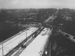
Vale of Avoca | |
|---|---|
 Vale of Avoca nears completion, November 3, 1924 | |
| Coordinates | 43°41′21″N 79°23′20″W / 43.689160°N 79.388882°W |
| Carries | 5 lanes of St. Clair Avenue (originally 4 lanes with 2 streetcar tracks) |
| Crosses | Vale of Avoca (ravine) |
| Locale | Toronto, Ontario, Canada |
| Other name(s) | St. Clair Viaduct |
| Maintained by | Toronto Transportation |
| Characteristics | |
| Design | Truss arch bridge |
| Total length | 155.1 m (509 ft) |
| Width | 19.7 m (65 ft) |
| Clearance above | 27 m (89 ft) |
| Clearance below | Yellow Creek |
| History | |
| Opened | 1924 |
| Statistics | |
| Daily traffic | St. Clair Avenue East |
| Toll | No |
| Location | |
 | |
Vale of Avoca is the name of a large viaduct which carries St. Clair Avenue East over a ravine of the same name, in Toronto, Canada. Located just east of Yonge Street, the current triple arch bridge, also known as the St. Clair Viaduct, was built to connect the well-established community of Deer Park with the developing community of Moore Park in the 1920s. The bridge replaced an older structure and straightened the alignment of St. Clair Avenue in the process.
A small channelized tributary of the Don River, known as Yellow Creek, weaves beneath the central span. Much of David A. Balfour Park (named for the Toronto city councillor) consists of a nature trail that winds through the Vale of Avoca Ravine; the park also includes a grassy recreational area near an inlet into which Yellow Creek flows.
The bridge and the ravine it crosses is named after a poem by Thomas Moore.