Vale of Glamorgan
Bwrdeistref Sirol Bro Morgannwg (Welsh) | |
|---|---|
| |
 Vale of Glamorgan shown within Wales | |
| Coordinates: 51°27′N 03°25′W / 51.450°N 3.417°W | |
| Sovereign state | United Kingdom |
| Country | Wales |
| Preserved county | South Glamorgan |
| Incorporated | 1 April 1974 |
| Unitary authority | 1 April 1996 |
| Administrative HQ | Barry |
| Government | |
| • Type | Principal council |
| • Body | Vale of Glamorgan Council |
| • Control | No overall control |
| • MPs | 2 MPs |
| • MSs | 2 MSs
|
| Area | |
| • Total | 128 sq mi (331 km2) |
| • Rank | 15th |
| Population (2022)[2] | |
| • Total | 133,492 |
| • Rank | 12th |
| • Density | 1,040/sq mi (403/km2) |
| Time zone | UTC+0 (GMT) |
| • Summer (DST) | UTC+1 (BST) |
| Postcode areas | |
| Dialling codes | 01656 |
| ISO 3166 code | GB-VGL |
| GSS code | W06000014 |
| Website | valeofglamorgan |
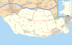
The Vale of Glamorgan (Welsh: Bro Morgannwg [ˈbroː mɔrˈɡanʊɡ]), locally referred to as The Vale, is a county borough in the south-east of Wales. It borders Bridgend County Borough to the west, Cardiff to the east, Rhondda Cynon Taf to the north, and the Bristol Channel to the south. With an economy based largely on agriculture and chemicals, it is the southernmost unitary authority in Wales. Attractions include Barry Island Pleasure Park, the Barry Tourist Railway, Medieval wall paintings in St Cadoc's Church, Llancarfan, Porthkerry Park, St Donat's Castle, Cosmeston Lakes Country Park and Cosmeston Medieval Village. The largest town is Barry. Other towns include Penarth, Llantwit Major, and Cowbridge. There are many villages in the county borough.
- ^ "Council". Vale of Glamorgan Council. Retrieved 6 August 2024.
- ^ a b "Mid-Year Population Estimates, UK, June 2022". Office for National Statistics. 26 March 2024. Retrieved 3 May 2024.


