Vallerotonda | |
|---|---|
| Comune di Vallerotonda | |
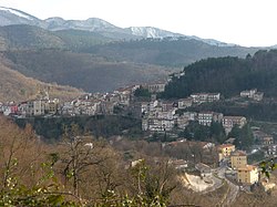
 View of Vallerotonda | |
| Coordinates: 41°33′N 13°55′E / 41.550°N 13.917°E | |
| Country | Italy |
| Region | Lazio |
| Province | Frosinone (FR) |
| Frazioni | Centro, Valvori, Cerreto and Cardito. |
| Government | |
| • Mayor | Gianfranco Verallo |
| Area | |
| • Total | 59 km2 (23 sq mi) |
| Elevation | 620 m (2,030 ft) |
| Population (28 February 2017)[2] | |
| • Total | 1,539 |
| • Density | 26/km2 (68/sq mi) |
| Demonym | Vallerotondesi |
| Time zone | UTC+1 (CET) |
| • Summer (DST) | UTC+2 (CEST) |
| Postal code | 03040 |
| Dialing code | 0776 |
| Patron saint | St. Peter |
| Saint day | 7 April |
| Website | Official website |
Vallerotonda (locally Vardónna) is a town and comune (municipality) in the region of Lazio in central Italy, in the province of Frosinone. The commune is situated on the Apennine Mountains and forms part of the Comino Valley.
- ^ "Superficie di Comuni Province e Regioni italiane al 9 ottobre 2011". Italian National Institute of Statistics. Retrieved 16 March 2019.
- ^ "Popolazione Residente al 1° Gennaio 2018". Italian National Institute of Statistics. Retrieved 16 March 2019.


