Vartdal Municipality
Vartdal herred | |
|---|---|
| Vartdalsstranden herred (historic name) | |
 View of Sætre in Vartdal | |
 Møre og Romsdal within Norway | |
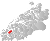
 Vartdal within Møre og Romsdal | |
| Coordinates: 62°18′01″N 06°04′59″E / 62.30028°N 6.08306°E | |
| Country | Norway |
| County | Møre og Romsdal |
| District | Sunnmøre |
| Established | 1 Jan 1895 |
| • Preceded by | Ulstein Municipality |
| Disestablished | 1 Jan 1964 |
| • Succeeded by | Ørsta Municipality |
| Administrative centre | Sætre |
| Area (upon dissolution) | |
| • Total | 125 km2 (48 sq mi) |
| Demonym | Vartdaling[1] |
| Time zone | UTC+01:00 (CET) |
| • Summer (DST) | UTC+02:00 (CEST) |
| ISO 3166 code | NO-1521[2] |
Vartdal is a former municipality in Møre og Romsdal county, Norway. The municipality existed from 1895 until its dissolution in 1965. The 125-square-kilometre (48 sq mi) area now sits in the northwestern part of the Ørsta municipality, along the Vartdalsfjorden. The administrative centre was the village Sætre, which is also known as Vartdal. Other villages in the municipality were Flåskjer and Nordre Vartdal. The main church for Vartdal was Vartdal Church, located in the village of Nordre Vartdal.[3]
- ^ "Navn på steder og personer: Innbyggjarnamn" (in Norwegian). Språkrådet.
- ^ Bolstad, Erik; Thorsnæs, Geir, eds. (26 January 2023). "Kommunenummer". Store norske leksikon (in Norwegian). Kunnskapsforlaget.
- ^ Thorsnæs, Geir, ed. (14 September 2015). "Vartdal - tidligere kommune". Store norske leksikon (in Norwegian). Kunnskapsforlaget. Retrieved 24 August 2019.