Ventura County | |
|---|---|
| County of Ventura | |
|
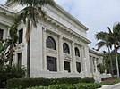
Images, from top down, left to right: Ventura City Hall in Old Town Ventura, Ojai Arcade in Ojai, a view of Camarillo, Ronald Reagan Presidential Library in Simi Valley, Point Mugu | |
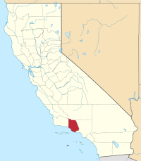
 Interactive map of Ventura County | |
 Location in the state of California | |
| Country | United States |
| State | California |
| Region | Greater Los Angeles California Central Coast |
| Created | March 22, 1872[1] |
| Established | January 1, 1873[2] |
| Named for | Mission San Buenaventura, which was named after Saint Bonaventure |
| County seat | Ventura |
| Largest city | Oxnard (population) Thousand Oaks (area) |
| Government | |
| • Type | Council–CEO |
| • Body | Board of Supervisors[3][4][5][6][7] |
| • Chair | Kelly Long (N.P.) |
| • Vice Chair | Janice S. Parvin (N.P.) |
| • Board of Supervisors[8] | |
| • Chief executive officer | Sevet Johnson |
| Area | |
| • Total | 2,208 sq mi (5,720 km2) |
| • Land | 1,843 sq mi (4,770 km2) |
| • Water | 365 sq mi (950 km2) |
| Highest elevation | 8,835 ft (2,693 m) |
| Population | |
| • Total | 843,843 |
| • Density | 458/sq mi (177/km2) |
| GDP | |
| • Total | $62.329 billion (2022) |
| Time zone | UTC−8 (Pacific Time Zone) |
| • Summer (DST) | UTC−7 (Pacific Daylight Time) |
| Area codes | 805/820, 818/747 |
| FIPS code | 06-111 |
| GNIS feature ID | 277320 |
| Congressional districts | 24th, 26th, 32nd |
| Website | ventura |
Ventura County (/vɛnˈtʊərə/ ) is a county located in the southern part of the U.S. state of California. As of the 2020 census, the population was 843,843.[10][13] The largest city is Oxnard, and the county seat is the city of Ventura.[14]
Ventura County comprises the Oxnard–Thousand Oaks–Ventura, CA Metropolitan Statistical Area, which is part of the Greater Los Angeles area (Los Angeles–Long Beach, CA Combined Statistical Area). It is also considered the southernmost county along the California Central Coast.[15]
Two of the Channel Islands are part of the county: Anacapa Island, which is the most visited island in Channel Islands National Park,[16] and San Nicolas Island.
- ^ "Ventura County". Geographic Names Information System. United States Geological Survey, United States Department of the Interior.
- ^ "About Us - Ventura County". Ventura.org. Ventura County Executive Office. Retrieved August 28, 2023.
- ^ "Matt LaVere, Supervisor, District 1 from Ventura County, California".
- ^ "Linda Parks, Supervisor, District 2 from Ventura County, California".
- ^ "Kelly Long, Supervisor, District 3 from Ventura County, California".
- ^ "Bob Huber, Supervisor, District 4 from Ventura County, California".
- ^ "Carmen Ramirez, Supervisor, District 5 from Ventura County, California".
- ^ "Board of Supervisors".
- ^ "Mount Pinos". Peakbagger.com. Retrieved March 13, 2015.
- ^ a b "State & County QuickFacts". United States Census Bureau. Retrieved December 25, 2021.
- ^ "Gross Domestic Product: All Industries in Ventura County, CA". Federal Reserve Economic Data. Federal Reserve Bank of St. Louis.
- ^ "American FactFinder". Archived from the original on June 2, 2013. Retrieved April 19, 2019.
- ^ "Ventura County, California". United States Census Bureau. Retrieved January 30, 2022.
- ^ "Find a County". National Association of Counties. Retrieved June 7, 2011.
- ^ "Central Coast". California State Parks. California Department of Recreation. Retrieved July 26, 2014.
- ^ "Anacapa Island History and Culture - Channel Islands National Park". U.S. National Park Service. Retrieved September 6, 2018.


