Victor, Idaho | |
|---|---|
 Post Office at Victor, Idaho, United States | |
| Motto: "A Town to Come Home To"[1] | |
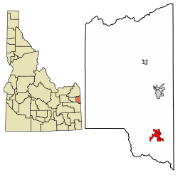
 Location of Victor in Teton County, Idaho. | |
| Coordinates: 43°36′11″N 111°6′44″W / 43.60306°N 111.11222°W | |
| Country | United States |
| State | Idaho |
| County | Teton |
| Government | |
| • Mayor | Will Frohlich |
| Area | |
| • Total | 2.65 sq mi (6.85 km2) |
| Elevation | 6,214 ft (1,894 m) |
| Population | |
| • Total | 2,157 |
| • Estimate (2021)[4] | 2,236 |
| • Density | 946.31/sq mi (365.34/km2) |
| Time zone | UTC-7 (Mountain (MST)) |
| • Summer (DST) | UTC-6 (MDT) |
| ZIP Code | 83455 |
| Area code(s) | 208, 986 |
| FIPS code | 16-84250 |
| GNIS feature ID | 0398304 |
| Website | www |
| Census | Pop. | Note | %± |
|---|---|---|---|
| 1920 | 277 | — | |
| 1930 | 250 | −9.7% | |
| 1940 | 294 | 17.6% | |
| 1950 | 431 | 46.6% | |
| 1960 | 240 | −44.3% | |
| 1970 | 241 | 0.4% | |
| 1980 | 323 | 34.0% | |
| 1990 | 292 | −9.6% | |
| 2000 | 840 | 187.7% | |
| 2010 | 1,928 | 129.5% | |
| 2020 | 2,157 | 11.9% | |
| U.S. Decennial Census[5] | |||
Victor is the largest city in Teton County, Idaho, United States. The population was 2,157 at the 2020 census, up from 1,928 in 2010, and 840 from 2000.[6] It is part of the Jackson, WY–ID Micropolitan Statistical Area.
Nearby Teton Pass is accessed south from Victor on State Highway 33, which continues east of the state border as Wyoming Highway 22 to Jackson Hole.
- ^ "City of Victor, Idaho". City of Victor, Idaho. Retrieved September 2, 2012.
- ^ "2019 U.S. Gazetteer Files". United States Census Bureau. Retrieved July 9, 2020.
- ^ Cite error: The named reference
wwwcensusgovwas invoked but never defined (see the help page). - ^ "Population and Housing Unit Estimates". United States Census Bureau. May 24, 2020. Retrieved May 27, 2020.
- ^ "Census of Population and Housing". Census.gov. Retrieved June 4, 2015.
- ^ "Explore Census Data". data.census.gov. Retrieved February 4, 2023.