| Victoria District Electoral Area | |
|---|---|
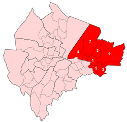
 Map showing Victoria wards within Belfast | |
| Area | 20.2 km2 (7.8 sq mi) |
| Population | 36,607 (2008 Estimate) |
| • Density | 1,812/km2 (4,690/sq mi) |
| District | |
| County | |
| Country | Northern Ireland |
| Sovereign state | United Kingdom |
| UK Parliament | |
| NI Assembly | |
Victoria was one of the nine district electoral areas (DEA) in Belfast, Northern Ireland, from 1985 to 2014, when it was mostly replaced by the Ormiston district.[1]
Located in the east of the city, the district elected seven members to Belfast City Council and contained the wards of Ballyhackamore; Belmont; Cherryvalley; Island; Knock; Stormont; and Sydenham. Victoria, along with wards from the neighbouring Pottinger district and Castlereagh Borough Council, formed the Belfast East constituency for the Northern Ireland Assembly and UK Parliament.
The district was bounded to the west by the Victoria Channel, to the north by Belfast Lough, to the northeast by North Down Borough Council, to the south and east by Castlereagh Borough Council and to the southwest by the Newtownards Road.
- ^ Final Northern Ireland super council recommendations, BBC News, 13 December 2013. Retrieved 24 May 2014