Native name: Kitlineq | |
|---|---|
 | |
 | |
| Geography | |
| Location | Northern Canada |
| Coordinates | 70°25′N 107°45′W / 70.417°N 107.750°W[1] |
| Archipelago | Arctic Archipelago |
| Area | 217,291 km2 (83,897 sq mi)[2] |
| Area rank | 8th |
| Length | 700 km (430 mi) |
| Width | 564–623 km (350–387 mi) |
| Highest elevation | 655 m (2149 ft) |
| Highest point | Unnamed |
| Administration | |
Canada | |
| Territories | Northwest Territories Nunavut |
| Largest settlement | Cambridge Bay, Nunavut (pop. 1,760[3]) |
| Demographics | |
| Population | 2,168[3][4] (2021) |
| Ethnic groups | Inuit |
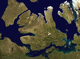
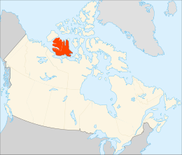
Victoria Island (Inuinnaqtun: Kitlineq)[5][6] is a large island in the Arctic Archipelago that straddles the boundary between Nunavut and the Northwest Territories of Canada. It is the eighth-largest island in the world, and at 217,291 km2 (83,897 sq mi)1 in area, it is Canada's second-largest island. It is nearly double the size of Newfoundland (111,390 km2 [43,010 sq mi]), and is slightly larger than the island of Great Britain (209,331 km2 [80,823 sq mi]) but smaller than Honshu (225,800 km2 [87,200 sq mi]). The western third of the island lies in the Inuvik Region of the Northwest Territories; the remainder is part of Nunavut's Kitikmeot Region. The population of 2,168 is divided between two settlements, the larger of which is Cambridge Bay (Nunavut) and the other Ulukhaktok (Northwest Territories).
The island is named after Queen Victoria, the Canadian sovereign from 1867 to 1901 (though she first became Queen in 1837). The features bearing the name "Prince Albert" are named after her consort, Albert.
- ^ "Victoria Island (Canada)". Geographical Names Data Base. Natural Resources Canada.
- ^ Cite error: The named reference
AOCwas invoked but never defined (see the help page). - ^ a b Cite error: The named reference
YCB2021censuswas invoked but never defined (see the help page). - ^ Cite error: The named reference
YHI2021censuswas invoked but never defined (see the help page). - ^ "Society-COPPER-ESKIMO". ukc.ac.uk. Archived from the original on 2008-05-14. Retrieved 2008-11-01.
- ^ Swann, Brian (2005). Wearing the Morning Star: Native American Song-Poems. Lincoln, Nebraska: University of Nebraska Press. p. 133. ISBN 0-8032-9340-2.