Vieux Fort (town) | |
|---|---|
 Vieux Fort | |
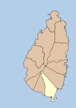
 Map of Saint Lucia showing location of Vieux Fort District and the town of Vieux Fort | |
| Coordinates: 13°43′41″N 60°57′14″W / 13.728°N 60.954°W | |
| Country | |
| District | Vieux Fort District |
| Founded | 18th Century |
| Named for | A nearby fort |
| Government | |
| • Governing body | Vieux Fort Council |
| Elevation | 1 m (3 ft) |
| Population (2005)[2] | |
| • Total | 15,750 (District)4,574 (town) |
| Time zone | UTC-4 (Eastern Caribbean Time Zone (ECT)) |
| Area code | 758 |
Vieux Fort is a town located near the southernmost point of Saint Lucia, a Caribbean island nation. It is named after a fort that used to watch out towards Saint Vincent towards the south. The population of the town was 4,574 in 2000 while the surrounding district of Vieux Fort has a total population of about 15,132 in 2010.[2][3]
- ^ "Vieux Fort". Freemeteo.
- ^ a b "Government Statistics". Government of Saint Lucia.
- ^ "Vieux Fort". GeoNames. Retrieved August 12, 2021.