Vila do Porto | |
|---|---|
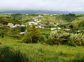
 The secluded village of Valverde, literally green-valley, near the eastern border of the parish of Vila do Porto | |
 Location of the civil parish of Vila do Porto, within the municipality of the same name | |
| Coordinates: 36°58′23″N 25°9′38″W / 36.97306°N 25.16056°W | |
| Country | |
| Auton. region | Azores |
| Island | Santa Maria |
| Municipality | Vila do Porto |
| Area | |
| • Total | 25.55 km2 (9.86 sq mi) |
| Elevation | 107 m (351 ft) |
| Population (2011) | |
| • Total | 3,119 |
| • Density | 120/km2 (320/sq mi) |
| Time zone | UTC−01:00 (AZOT) |
| • Summer (DST) | UTC±00:00 (AZOST) |
| Postal code | 9580-525 |
| Area code | 292 |
| Patron | Nossa Senhora da Assunção |
Vila do Porto (Portuguese pronunciation: [ˈvilɐ ðu ˈpoɾtu]) is a civil parish in the municipality of Vila do Porto, located on the island of Santa Maria, in the Portuguese autonomous region of Azores. It is the southernmost and easternmost parish in the archipelago of Azores. The population in 2011 was 3,119,[1] in an area of 25.55 km².[2]
- ^ Instituto Nacional de Estatística
- ^ Eurostat Archived October 7, 2012, at the Wayback Machine
