| Virgin River Virgen River, Rio de la Virgen[1] | |
|---|---|
 Virgin River in Zion National Park | |
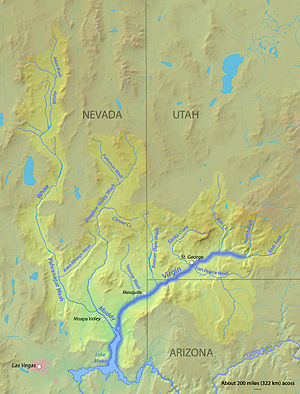
 The Virgin River watershed | |
| Location | |
| Country | United States |
| State | Nevada, Utah, Arizona |
| Physical characteristics | |
| Source | confluence of East Fork and North Fork |
| • location | Navajo Reservoir, Dixie National Forest, Utah |
| • coordinates | 37°9′44″N 113°0′51″W / 37.16222°N 113.01417°W[2] |
| • elevation | 3,763 ft (1,147 m)[3] |
| Mouth | Colorado River |
• location | Lake Mead, Lake Mead National Recreation Area |
• coordinates | 36°8′46″N 114°24′59″W / 36.14611°N 114.41639°W[2] |
• elevation | 1,204 ft (367 m)[2] |
| Length | 162 mi (261 km)[3] |
| Basin size | 12,250 sq mi (31,700 km2)approx. |
| Discharge | |
| • location | St. George, Utah[4] |
| • average | 183 cu ft/s (5.2 m3/s)[4] |
| • minimum | 0 cu ft/s (0 m3/s) |
| • maximum | 55,000 cu ft/s (1,600 m3/s) |
| Basin features | |
| River system | North and East Forks Virgin River |
| Tributaries | |
| • left | Fort Pearce Wash |
| • right | Ash Creek, Santa Clara River, Beaver Dam Wash, Toquop Wash, Muddy River |
| Type | Wild 145.4 miles (234.0 km) Scenic 11.3 miles (18.2 km) Recreational 12.6 miles (20.3 km) |
| Designated | March 30, 2009[5] |
The Virgin River is a tributary of the Colorado River in the U.S. states of Utah, Nevada, and Arizona. The river is about 162 miles (261 km) long.[3] It was designated Utah's first wild and scenic river in 2009, during the centennial celebration of Zion National Park.
- ^ Byrd H. Granger (1983). Arizona's Names (X Marks the Place). Tucson, Arizona: The Falconer Publishing Company. p. 652.
- ^ a b c U.S. Geological Survey Geographic Names Information System: Virgin River
- ^ a b c Calculated with Google Maps and Google Earth
- ^ a b "USGS Gage #09413500 on the Virgin River near St. George, UT" (PDF). National Water Information System. U.S. Geological Survey. 2010. Retrieved 2011-10-16.
- ^ "National Wild and Scenic Rivers System". rivers.gov. National Wild and Scenic Rivers System. Retrieved 2023-01-05.