| Vltava | |
|---|---|
 Vltava in Prague | |
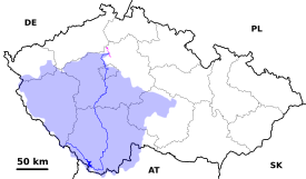  The course and drainage basin of the Vltava from its source to its confluence with the Elbe (magenta) | |
| Location | |
| Country | Czech Republic |
| Regions | |
| Cities | |
| Physical characteristics | |
| Source | Černý potok |
| • location | Černá hora, Bohemian Forest |
| • coordinates | 48°58′29″N 13°33′39″E / 48.97472°N 13.56083°E |
| • elevation | 1,172 m (3,845 ft) |
| Mouth | Elbe |
• location | Mělník |
• coordinates | 50°20′29″N 14°28′30″E / 50.34139°N 14.47500°E |
• elevation | 155 m (509 ft) |
| Length | 430.3 km (267.4 mi) |
| Basin size | 28,090 km2 (10,850 sq mi) |
| Discharge | |
| • average | 149.9 m3/s (5,290 cu ft/s) |
| Basin features | |
| Progression | Elbe→ North Sea |
| Tributaries | |
| • left | Otava, Berounka |
| • right | Lužnice, Sázava |
 | |
The Vltava (/ˈvʊltəvə, ˈvʌl-/ VU(U)L-tə-və,[1][2][3] Czech: [ˈvl̩tava] ; German: Moldau [ˈmɔldaʊ] ) is the longest river in the Czech Republic, running southeast along the Bohemian Forest and then north across Bohemia, through Český Krumlov, České Budějovice, and Prague, and finally merging with the Elbe at Mělník. It is commonly referred to as the "Czech national river".[4]
- ^ Wells, John C. (2008), Longman Pronunciation Dictionary (3rd ed.), Longman, ISBN 9781405881180
- ^ "Vltava" (US) and "Vltava". Lexico UK English Dictionary. Oxford University Press. Archived from the original on 2020-03-22.
- ^ "Vltava". Merriam-Webster.com Dictionary. Merriam-Webster. Retrieved March 31, 2019.
- ^ Mahoney, William (2001). The History of the Czech Republic and Slovakia. ABC-CLIO. p. 3. ISBN 0313363064.