Voies
Βοιές | |
|---|---|
 Castle of Agia Paraskevi and Vatika region | |
| Coordinates: 36°30′N 23°4′E / 36.500°N 23.067°E | |
| Country | Greece |
| Administrative region | Peloponnese |
| Regional unit | Laconia |
| Municipality | Monemvasia |
| Area | |
| • Municipal unit | 215.5 km2 (83.2 sq mi) |
| Elevation | 15 m (49 ft) |
| Population (2021)[1] | |
| • Municipal unit | 7,235 |
| • Municipal unit density | 34/km2 (87/sq mi) |
| Time zone | UTC+2 (EET) |
| • Summer (DST) | UTC+3 (EEST) |
| Postal code | 230 53 |
| Area code(s) | 27340 |
| Vehicle registration | ΑΚ |
| Website | VisitVatika.gr |
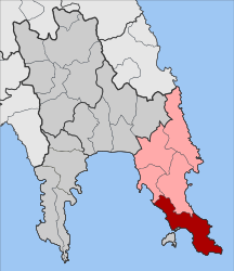
Voies (Greek: Βοιές Greek pronunciation: [/viˈes/], feminine plural) is a former municipality in Laconia, Peloponnese, Greece. Since the 2011 local government reform it is part of the municipality Monemvasia, of which it is a municipal unit.[2] The municipal unit has an area of 215.527 km2.[3] It is on the southern tip of Cape Malea. It is a predominantly agricultural region with a few minor villages and one dominant town. Vatika is the common term for the area, but Voies is used in a more official context, particularly for postal situations. Voion, the genitive, is used for description: for example, to differentiate the village of Agios Nikolaos in Voies from other villages and towns of the same name, one would use Agios Nikolaos Voion. Neapoli is the administrative capital of the municipality, and is also the urban center to the numerous villages that surround the hinterland.
In the Kato Kastania village of Voies is found the large and colorful Kastania Cave.[4]
- ^ "Αποτελέσματα Απογραφής Πληθυσμού - Κατοικιών 2021, Μόνιμος Πληθυσμός κατά οικισμό" [Results of the 2021 Population - Housing Census, Permanent population by settlement] (in Greek). Hellenic Statistical Authority. 29 March 2024.
- ^ "ΦΕΚ B 1292/2010, Kallikratis reform municipalities" (in Greek). Government Gazette.
- ^ "Population & housing census 2001 (incl. area and average elevation)" (PDF) (in Greek). National Statistical Service of Greece.
- ^ "Kastania Cave, Kato Kastania, Greece", Atlas Obscura

