Vuzenica | |
|---|---|
 | |
| Coordinates: 46°35′48″N 15°10′08″E / 46.59667°N 15.16889°E | |
| Country | |
| Traditional region | Styria |
| Statistical region | Carinthia |
| Municipality | Vuzenica |
| Area | |
| • Total | 2.9 km2 (1.1 sq mi) |
| Elevation | 364.9 m (1,197.2 ft) |
| Population | |
| • Total | 1,522 |
| • Density | 520/km2 (1,400/sq mi) |
| [3] | |
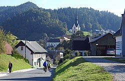
Vuzenica (pronounced [ʋuzɛˈniːtsa], German: Saldenhofen[4]) is a major settlement in northern Slovenia. It is the seat of the Municipality of Vuzenica. It lies on the right bank of the Drava River and extends south into the Pohorje Hills. The municipality is included in the Carinthia Statistical Region, which is in the Slovenian portion of the historical Duchy of Styria.[5]
- ^ Razpotnik, Barica (2020-06-08). "On 1 January 2020, 2,095,861 residents of Slovenia lived in 5,978 settlements; 57 settlements were unpopulated" (Press release). Ljubljana: Statistical Office of the Republic of Slovenia. Retrieved 2021-01-09.
final data (XLS attachment)
- ^ Prebivalci po spolu, občine in naselja, Slovenija, 1. januar 2020 [Population by sex, municipalities and resorts, Slovenia, 1 January 2020]. Statistical Office of the Republic of Slovenia (XLS) (in Slovenian). Ljubljana. 2020-06-08. Retrieved 2021-01-09.
(note: for Vuzenica, the municipality is at code 141, followed immediately by its settlements at codes 141001–141105)
- ^ Statistical Office of the Republic of Slovenia
- ^ Leksikon občin kraljestev in dežel zastopanih v državnem zboru, vol. 4: Štajersko. Vienna: C. Kr. Dvorna in Državna Tiskarna. 1904. p. 264.
- ^ Vuzenica municipal site

