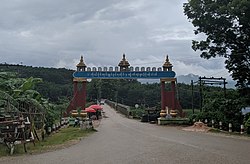
Wa Self-Administered Division
ဝ ကိုယ်ပိုင်အုပ်ချုပ်ခွင့်ရ တိုင်း | |
|---|---|
 | |
 Location in Shan State | |
| Coordinates: 22°10′00″N 99°10′00″E / 22.16667°N 99.16667°E | |
| Country | |
| State | Shan State |
| Created | 20 August 2010 |
| De facto ceased | January 2024[1] |
| Capital | Hopang |
| Government | |
| • Chairman of the Leading Body | vacant |
| Area | |
| • Total | 12,433 km2 (4,800 sq mi) |
| Elevation | 524 m (1,719 ft) |
| Population | |
| • Total | 558,000 |
| Demonym | Wa |
| Time zone | UTC+6:30 (MMT) |
The Wa Self-Administered Division (Burmese: ဝ ကိုယ်ပိုင်အုပ်ချုပ်ခွင့်ရ တိုင်း [wa̰ kòbàɪɰ̃ ʔoʊʔtɕʰoʊʔ kʰwɪ̰ɰ̃ja̰ táɪɰ̃]; Chinese: 佤自治州; Wade–Giles: Wa Tzŭ-chih-chou) is an autonomous, self-administered division of Myanmar (Burma). Its official name was announced by decree on 20 August 2010.[3]
Myanmar's government declared the area to be administered by the Wa people, under the official name Wa Special Region 2. Its territory is entirely under the control of the de facto independent Wa State.[4] Hopang and Pan Lon were directly controlled by the Tatmadaw until their transfer to Wa State in January 2024.[1][5]
- ^ a b News Bureau of Wa State (佤邦新闻局) (13 January 2024). 佤邦人民政府就户板地区接管工作顺利完成 (in Chinese). “佤邦之音”微信公众号. Archived from the original on 20 January 2024.
- ^ GoogleEarth
- ^ "တိုင်းခုနစ်တိုင်းကို တိုင်းဒေသကြီးများအဖြစ် လည်းကောင်း၊ ကိုယ်ပိုင်အုပ်ချုပ်ခွင့်ရ တိုင်းနှင့် ကိုယ်ပိုင်အုပ်ချုပ်ခွင့်ရ ဒေသများ ရုံးစိုက်ရာ မြို့များကို လည်းကောင်း ပြည်ထောင်စုနယ်မြေတွင် ခရိုင်နှင့်မြို့နယ်များကို လည်းကောင်း သတ်မှတ်ကြေညာ". Weekly Eleven News (in Burmese). 20 August 2010. Retrieved 23 August 2010.
- ^ "Protected by China, Wa Is Now a de Facto Independent State". The Irrawaddy. 23 April 2019. Retrieved 1 October 2019.
- ^ "Myanmar Military Bows to Powerful Ethnic Army, Gives it More Towns Near China Border". The Irrawaddy. 15 January 2024. Retrieved 20 January 2024.