Waikuku | |
|---|---|
Rural settlement | |
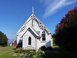
 Waikuku Methodist Church | |
 | |
| Coordinates: 43°17′31″S 172°41′06″E / 43.292°S 172.685°E | |
| Country | New Zealand |
| Region | Canterbury |
| Territorial authority | Waimakariri District |
| Ward | Kaiapoi-Woodend Ward |
| Community | Woodend-Sefton Community |
| Electorates |
|
| Government | |
| • Territorial Authority | Waimakariri District Council |
| • Regional council | Environment Canterbury |
| • Mayor of Waimakariri | Dan Gordon |
| • Waimakariri MP | Matthew Doocey |
| • Te Tai Tonga MP | Tākuta Ferris |
| Area | |
| • Total | 1.60 km2 (0.62 sq mi) |
| Population (June 2024)[2] | |
| • Total | 180 |
| • Density | 110/km2 (290/sq mi) |
| Time zone | UTC+12 (NZST) |
| • Summer (DST) | UTC+13 (NZDT) |
| Postcode | 7473 |
| Area code | 03 |
Waikuku is a small town in the Canterbury region of New Zealand, which sits 28 km north of central Christchurch. Waikuku lies 11.8 km (7.3 mi) south of Leithfield on state highway 1 and 3 km (1.9 mi) north of Woodend. In 1901 there were 86 people resident in Waikuku according to that year's census.[3] Waikuku settlement had a population of 156 people at the time of the 2018 Census.[4] It is popular with both those that commute into work in Christchurch each day and with owners of holiday houses.[5][6] Waikuku was home to rope and twine works. This business started off using flax from local swamps. It closed in 1987.[3][5] The nearby sandy beach and pine forests are popular with surfers, swimmers, campers and horse-riders, and the large estuary of the Ashley River hosts many species of birds.[7]
Just south of Waikuku, on Preeces Road, are the remains of the Kaiapoi Pa, an important trading centre for Ngāi Tahu in the 18th century.
- ^ Cite error: The named reference
Areawas invoked but never defined (see the help page). - ^ "Aotearoa Data Explorer". Statistics New Zealand. Retrieved 26 October 2024.
- ^ a b "Waikuku | NZETC". nzetc.victoria.ac.nz. Retrieved 21 December 2020.
- ^ Cite error: The named reference
Census 2018was invoked but never defined (see the help page). - ^ a b Taonga, New Zealand Ministry for Culture and Heritage Te Manatu. "Kaiapoi district". teara.govt.nz. Retrieved 21 December 2020.
- ^ Barclay, Chris (9 November 2020). "Buyers snap up quintessential Canterbury baches". Otago Daily Times Online News. Retrieved 21 December 2020.
- ^ "Ashley-Rakahuri". Ashley-Rakahuri Rivercare Group. Archived from the original on 3 July 2013. Retrieved 12 April 2013.