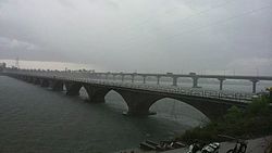
| Wainganga River | |
|---|---|
 Wainganga River in Bhandara City | |
| Location | |
| Country | India |
| State | Madhya Pradesh, Maharashtra |
| Cities | Chhapara, Seoni, Tirora, Bhandara |
| Physical characteristics | |
| Source | Mundara |
| • location | MUNDARA, Seoni District, Madhya Pradesh |
| • coordinates | 21°57′N 79°34′E / 21.950°N 79.567°E |
| • elevation | 1,048 m (3,438 ft) |
| Mouth | Pranahita River |
• location | Adilabad district, Gadchiroli District, border of the 2 districts |
• coordinates | 19°35′24″N 79°47′59″E / 19.59000°N 79.79972°E |
• elevation | 146 m (479 ft) |
| Length | 569 km (354 mi) |
| Basin size | 43,658 km2 (16,856 sq mi) |
| Basin features | |
| Tributaries | |
| • left | Thanwar River, Nahara River, Sonbiri River, Bagh River, Chulband River, Gadhavi River, Triveni River, Kathani River |
| • right | Hirri River, Sarrati River, Chandan River, Bawanthari River, Sur River, Kanhan River, Andhari River |
The Wainganga[a] is a river in India originating in the Mahadeo Hills in Mundara in Gondwana region near the village Gopalganj in Seoni, Madhya Pradesh. It is a key tributary of the Godavari. The river flows south in a winding course through the states of Madhya Pradesh and Maharashtra, roughly 580 km (360 mi). After joining the Wardha River, the united stream, which is known as the Pranahita River, empties into the Godavari River at Kaleshwaram, Telangana.
Cite error: There are <ref group=lower-alpha> tags or {{efn}} templates on this page, but the references will not show without a {{reflist|group=lower-alpha}} template or {{notelist}} template (see the help page).