| Waitpinga South Australia | |||||||||||||||
|---|---|---|---|---|---|---|---|---|---|---|---|---|---|---|---|
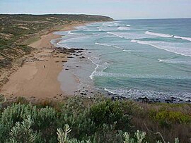
 Waitpinga beach viewed from the Heysen Trail | |||||||||||||||
| Coordinates | 35°36′0″S 138°32′0″E / 35.60000°S 138.53333°E | ||||||||||||||
| Population | 222 (2011 census)[1] | ||||||||||||||
| Postcode(s) | 5211[2] | ||||||||||||||
| Location |
| ||||||||||||||
| LGA(s) | City of Victor Harbor[3] District Council of Yankalilla[4] | ||||||||||||||
| Region | Fleurieu and Kangaroo Island[5] | ||||||||||||||
| County | County of Hindmarsh[4] | ||||||||||||||
| State electorate(s) | Finniss[6] | ||||||||||||||
| Federal division(s) | Mayo[7] | ||||||||||||||
| |||||||||||||||
| |||||||||||||||
| Footnotes | Location[2][4] Climate[8] Adjoining localities[4][3] | ||||||||||||||
Waitpinga (locally /waɪˈpɪŋɡə/ wy-PING-gə) is a locality in the Australian state of South Australia located about 75 kilometres (47 miles) south of the state capital of Adelaide and about 10 kilometres (6.2 miles) southwest of the municipal seat of Victor Harbor.[2][4]
At the 2011 census, Waitpinga had a population of 165.[1] The name is of Aboriginal origin, meaning home of the winds.
Waitpinga's coastline includes the following beaches popular for activities such as fishing and surfing – Coolawang, King Head, Parsons Beach and Waitpinga.[9] Waitpinga Beach is a popular surfing and fishing beach, good for salmon and mullet and characterized by its reddish sand.[citation needed] It is an exposed beach that has a consistent surf and the best surfing this close to Adelaide.[citation needed] It is also one of the most dangerous beaches for surfers or swimmers without experience in rough conditions.[citation needed] Swimmers can easily become trapped in rips and rough seas and there is no life saving service at this beach.[10] There are rough waves, powerful rips and sharks who come to feed on the salmon and mullet.[citation needed]
Waitpinga is located within the federal division of Mayo, the state electoral district of Finniss and the local government areas of the City of Victor Harbor and the District Council of Yankalilla.[7][6][4]
- ^ a b Australian Bureau of Statistics (31 October 2012). "Waitpinga (State Suburb)". 2011 Census QuickStats. Retrieved 3 February 2016.
- ^ a b c "Waitpinga, South Australia". Postcodes Australia. Retrieved 3 August 2015.
- ^ a b "Suburbs Map – District" (PDF). City of Victor Harbor. Retrieved 31 July 2015.
- ^ a b c d e f "Search result for "Waitpinga(Locality Bounded)" (Record no SA0016159) with the following layers selected – "Suburbs and Localities" and "Locl Government Areas"". Department of Planning, Transport and Infrastructure. Retrieved 27 April 2016.
- ^ "Limestone Coast SA Government region" (PDF). The Government of South Australia. Retrieved 9 September 2016.
- ^ a b "District of Finniss Background Profile". ELECTORAL COMMISSION SA. Retrieved 2 August 2015.
- ^ a b "Federal electoral division of Mayo, boundary gazetted 16 December 2011" (PDF). Australian Electoral Commission. Retrieved 2 August 2015.
- ^ "Summary statistics VICTOR HARBOR (ENCOUNTER BAY)". Commonwealth of Australia, Bureau of Meteorology. Retrieved 3 February 2016.
- ^ "WaitpingaUNPATROLLED BEACH". Surf Life Saving Australia. Retrieved 2 August 2015.
- ^ Stewart F, 2009, Hero Brett Perry saved three lives at Waitpinga, The Advertiser, Adelaide, retrieved 19 October 09
