Wake County | |
|---|---|
 Location within the U.S. state of North Carolina | |
 North Carolina's location within the U.S. | |
| Coordinates: 35°47′N 78°39′W / 35.79°N 78.65°W | |
| Country | |
| State | |
| Founded | 1771 |
| Named for | Margaret Wake |
| Seat | Raleigh |
| Largest community | Raleigh |
| Area | |
• Total | 857.02 sq mi (2,219.7 km2) |
| • Land | 834.59 sq mi (2,161.6 km2) |
| • Water | 22.43 sq mi (58.1 km2) 2.62% |
| Population (2020) | |
• Total | 1,129,410 |
• Estimate (2023) | 1,190,275 |
| • Density | 1,300/sq mi (510/km2) |
| Time zone | UTC−5 (Eastern) |
| • Summer (DST) | UTC−4 (EDT) |
| Congressional districts | 2nd, 4th, 13th |
| Website | www |
Wake County is a county located in the U.S. state of North Carolina. As of the 2020 census, its population was 1,129,410,[1] making it North Carolina's most populous county. From July 2005 to July 2006, Wake County was the 9th-fastest growing county in the United States,[2] with Cary and Raleigh being the 8th- and 15th-fastest growing communities, respectively.[3]
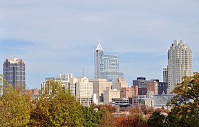
Its county seat is Raleigh,[4] which is also the state capital. Eleven other municipalities are in Wake County, the largest of which is the town of Cary, the third-most populous city of the Research Triangle region and the seventh-most populous municipality in North Carolina.
It is governed by the Wake County Board of Commissioners, coterminous with the Wake County Public School System, with law enforcement provided by the Wake County Sheriff's Department. It is also part of the wider Triangle J Council of Governments, which governs regional planning.
- ^ Cite error: The named reference
2020CensusQuickFactswas invoked but never defined (see the help page). - ^ Christie, Les. "Wake County, North Carolina". CNN. Retrieved May 27, 2010.
- ^ "The 258 fastest growing U.S. cities". CNN. June 27, 2007. Retrieved May 27, 2010.
- ^ "Find a County". National Association of Counties. Retrieved June 7, 2011.


