Wakefield-Peacedale, Rhode Island | |
|---|---|
 Peace Dale Congregational Church | |
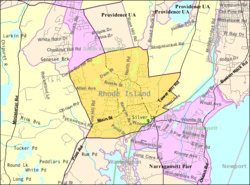
 Map of Wakefield-Peacedale with its boundaries in 2000 | |
| Coordinates: 41°26′28″N 71°29′57″W / 41.44111°N 71.49917°W | |
| Country | United States |
| State | Rhode Island |
| County | Washington |
| Area | |
| • Total | 5.1 sq mi (13.2 km2) |
| • Land | 4.9 sq mi (12.6 km2) |
| • Water | 0.2 sq mi (0.6 km2) |
| Population (2010) | |
| • Total | 8,487 |
| • Density | 1,739.4/sq mi (671.6/km2) |
| Time zone | UTC-5 (Eastern (EST)) |
| • Summer (DST) | UTC-4 (EDT) |
| FIPS code | 44-73130[1] |
Wakefield-Peacedale (listed as "Wakefield-Peace Dale" by the United States Census Bureau) is a census-designated place (CDP) in the town of South Kingstown in Washington County, Rhode Island, United States that includes the villages of Peace Dale and Wakefield. The population was 8,487 at the 2010 census.
- ^ "U.S. Census website". United States Census Bureau. Retrieved January 31, 2008.