| Waldo Canyon Fire | |
|---|---|
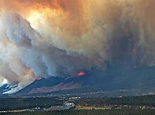
 The fire moving towards the Mountain Shadows area of Colorado Springs | |
| Date(s) | June 23, 2012 – July 10, 2012 |
| Location | San Isabel National Forest, Colorado Springs, Colorado |
| Coordinates | 38°53′24″N 104°52′19″W / 38.89°N 104.872°W |
| Statistics[1] | |
| Burned area | 18,247 acres (74 km2) |
| Impacts | |
| Deaths | 2 |
| Structures destroyed | 346 |
| Map | |
The Waldo Canyon fire was a forest fire that started approximately 4 miles (6.4 km) northwest of Colorado Springs, Colorado on June 23, 2012, and was declared 100 percent contained on July 10, 2012, after no smoke plumes were visible on a small portion of the containment line on Blodgett Peak. The fire was active in the Pike National Forest and adjoining areas, covering a total of 18,247 acres (29 sq mi; 74 km2).[2] The fire had caused the evacuation of over 32,000 residents of Colorado Springs, Manitou Springs and Woodland Park, several small mountain communities along the southwestern side of U.S. Highway 24, and partial evacuation of the United States Air Force Academy.[3][4] There were 346 homes destroyed by the fire.[5] U.S. Highway 24, a major east–west road, was closed in both directions.[6] The Waldo Canyon Fire resulted in insurance claims totaling more than US $453.7 million.[7] It was the most destructive fire in Colorado state history, as measured by the number of homes destroyed, until the Black Forest Fire surpassed it almost a year later when it consumed 486 homes and damaged 28 others.[8][9]
- ^ "Colorado Springs Mayor: Fire Has Destroyed '346 Homes'". CBS4 Denver. June 28, 2012.
- ^ "Waldo Canyon Fire Update 6-30-12 Pm". InciWeb. Retrieved July 1, 2012.
- ^ "Waldo Canyon Fire forces 11,000 people from their homes". The Denver Post. June 24, 2012. Retrieved June 24, 2012.
- ^ "Colorado wildfire: Waldo Canyon fire now at 18,500 acres". denverpost. June 28, 2012. Retrieved June 28, 2012.
- ^ St. Louis-Sanchez, Maria (September 23, 2012). "Waldo Canyon fire: Tally of destruction remains imprecise". The Gazette. Retrieved September 24, 2012.
- ^ "600 Personnel Working To Contain 4,500 Acre Waldo Canyon Fire". KKTV. June 25, 2012. Archived from the original on June 26, 2012. Retrieved June 26, 2012.
- ^ Murphy, Connie (June 21, 2013). "Insurance cost of Waldo Canyon fire: $453 million". KOAA.com. Archived from the original on December 2, 2013. Retrieved June 22, 2013.
- ^ Parker, Ryan; Jordan Steffen; Zahira Torres (June 14, 2013). "2 confirmed dead in Black Forest fire; 379 homes destroyed". The Denver Post. Archived from the original on June 18, 2013. Retrieved June 19, 2013.
- ^ "Black Forest Fire - Residences" (PDF). El Paso County Sheriff's Office. June 21, 2013.
