Walhalla, North Dakota | |
|---|---|
 Walhalla Trading Post | |
| Motto: "Heart of the Rendezvous Region"[1] | |
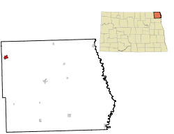
 Location of Walhalla, North Dakota | |
| Coordinates: 48°55′16″N 97°55′03″W / 48.92111°N 97.91750°W | |
| Country | United States |
| State | North Dakota |
| County | Pembina |
| Established | 1845 |
| Founded | 1871 |
| Government | |
| • City Auditor | Melissa Gapp |
| Area | |
| • Total | 1.05 sq mi (2.72 km2) |
| • Land | 1.03 sq mi (2.68 km2) |
| • Water | 0.02 sq mi (0.04 km2) |
| Elevation | 991 ft (302 m) |
| Population | |
| • Total | 893 |
| • Estimate (2022)[5] | 897 |
| • Density | 862.80/sq mi (332.99/km2) |
| Time zone | UTC-6 (Central (CST)) |
| • Summer (DST) | UTC-5 (CDT) |
| ZIP code | 58282 |
| Area code | 701 |
| FIPS code | 38-82980 |
| GNIS feature ID | 1036314[3] |
| Highways | ND 32 |
| Website | walhalland.org |
Walhalla is a city in Pembina County, North Dakota, United States. It sits on the banks of the Pembina River, five miles (8 km) from the border with Manitoba (Canada) and approximately 45 mi (72 km) from the border with Minnesota. The population was 893 at the 2020 census.[4]
- ^ "CITY OF WALHALLA, ND". CITY OF WALHALLA, ND. Retrieved August 16, 2012.
- ^ "ArcGIS REST Services Directory". United States Census Bureau. Retrieved September 20, 2022.
- ^ a b U.S. Geological Survey Geographic Names Information System: Walhalla, North Dakota
- ^ a b "Explore Census Data". United States Census Bureau. Retrieved November 3, 2023.
- ^ Cite error: The named reference
USCensusEst2022was invoked but never defined (see the help page).