Walled Lake, Michigan | |
|---|---|
| City of Walled Lake | |
 Facing east along East Maple Road | |
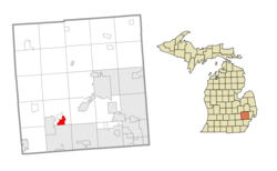
 Location within Oakland County | |
| Coordinates: 42°32′16″N 83°28′52″W / 42.53778°N 83.48111°W | |
| Country | United States |
| State | Michigan |
| County | Oakland |
| Incorporated | 1954 |
| Government | |
| • Type | Mayor–council |
| • Mayor | Linda Ackley |
| • Clerk | Jennifer Stuart |
| • Manager | L. Dennis Whitt |
| Area | |
• City | 2.39 sq mi (6.19 km2) |
| • Land | 2.21 sq mi (5.72 km2) |
| • Water | 0.18 sq mi (0.47 km2) |
| Elevation | 942 ft (287 m) |
| Population (2020) | |
• City | 7,250 |
| • Density | 3,282.03/sq mi (1,267.48/km2) |
| • Metro | 4,296,250 (Metro Detroit) |
| Time zone | UTC-5 (Eastern (EST)) |
| • Summer (DST) | UTC-4 (EDT) |
| ZIP code(s) | 48390, 48391 |
| Area code(s) | 248 |
| FIPS code | 26-83060[2] |
| GNIS feature ID | 1615720[3] |
| Website | Official website |
Walled Lake is a city in Oakland County in the U.S. state of Michigan. A northwestern suburb of Detroit, Walled Lake is located roughly 32 miles (51.5 km) northwest of downtown Detroit. As of the 2020 census, the city had a population of 7,246.[4]
- ^ "2020 U.S. Gazetteer Files". United States Census Bureau. Retrieved May 21, 2022.
- ^ "U.S. Census website". United States Census Bureau. Retrieved January 31, 2008.
- ^ U.S. Geological Survey Geographic Names Information System: Walled Lake, Michigan
- ^ "U.S. Census Bureau QuickFacts: Walled Lake city, Michigan, United States". www.census.gov. Retrieved November 7, 2024.

