| Walnut Creek | |
|---|---|
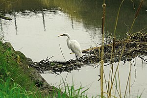
 Secondary beaver dam on lower Walnut Creek provides happy hunting perch for a great egret. Courtesy Cheryl Reynolds, Worth a Dam, 2013 | |
 Walnut Creek watershed (Interactive map) | |
| Location | |
| Country | United States |
| State | California |
| Region | Contra Costa County |
| Cities | Walnut Creek, Pleasant Hill, Four Corners, Concord, Pacheco, Vine Hill, Mococo, Martinez |
| Physical characteristics | |
| Source | Confluence of Las Trampas Creek and Tice Creek |
| • location | Walnut Creek, California 375338N 1220335W |
| • coordinates | 37°53′38″N 122°3′35″W / 37.89389°N 122.05972°W[2] |
| • elevation | 144 ft (44 m) |
| Mouth | Suisun Bay |
• location | Martinez, California |
• coordinates | 38°1′27″N 122°4′13″W / 38.02417°N 122.07028°W[2] |
• elevation | 2 ft (0.61 m) |
| Basin size | 146 sq mi (380 km2) |
The Walnut Creek mainstem is a 12.3-mile-long (19.8-kilometer)[3] northward-flowing stream in northern California. The Walnut Creek watershed lies in central Contra Costa County, California and drains the west side of Mount Diablo and the east side of the East Bay Hills.[4] The Walnut Creek mainstem is now mostly a concrete or earthen flood control channel until it reaches Pacheco Creek[5] on its way to Suisun Bay. Walnut Creek was named for the abundant native Northern California walnut trees (Juglans hindsii) which lined its banks historically. The city of Walnut Creek, California was named for the creek when its post office was established in the 1860s.[1]
- ^ a b c Gudde, Erwin G. (1949). California Place Names: A Geographical Dictionary. Berkeley, California: University of California Press.
- ^ a b U.S. Geological Survey Geographic Names Information System: Walnut Creek
- ^ U.S. Geological Survey. National Hydrography Dataset high-resolution flowline data. The National Map, accessed October 20, 2020
- ^ Contra Costa County Watershed Atlas (PDF) (Report). Martinez, California: Contra Costa County Community Development Department. November 2003. Archived from the original (PDF) on 2020-10-29. Retrieved October 29, 2020.
- ^ U.S. Geological Survey Geographic Names Information System: Pacheco Creek