This article needs additional citations for verification. (April 2020) |
| Walsden | |
|---|---|
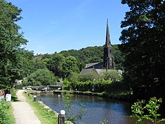
 Travis Mill Lock and St Peter's Church, Walsden | |
Location within West Yorkshire | |
| OS grid reference | SD934220 |
| Civil parish | |
| Metropolitan borough | |
| Metropolitan county | |
| Region | |
| Country | England |
| Sovereign state | United Kingdom |
| Post town | TODMORDEN |
| Postcode district | OL14 |
| Dialling code | 01706 |
| Police | West Yorkshire |
| Fire | West Yorkshire |
| Ambulance | Yorkshire |
| UK Parliament | |
Walsden (/ˈwɒlzdən/; WOLZ-dən) is a large village in the civil parish of Todmorden in the Metropolitan Borough of Calderdale, West Yorkshire, England.
It was historically partially administered in Lancashire (the Walsden Water as tributary to the Calder serving as the county boundary), and close to the modern boundary with Greater Manchester. It lies along the A6033 Keighley to Littleborough road in the Walsden Valley, a branch of the Upper Calder Valley, and is 2 miles (3.2 km) south of Todmorden and 4 miles (6.4 km) north of Littleborough.

