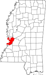
Warren County | |
|---|---|
 Warren County Courthouse in Vicksburg, built c. 1940, located across from the Old Courthouse Museum. | |
 Location within the U.S. state of Mississippi | |
 Mississippi's location within the U.S. | |
| Coordinates: 32°22′N 90°51′W / 32.36°N 90.85°W | |
| Country | |
| State | |
| Founded | December 22, 1809 |
| Named for | Joseph Warren |
| Seat | Vicksburg |
| Largest city | Vicksburg |
| Area | |
| • Total | 619 sq mi (1,600 km2) |
| • Land | 589 sq mi (1,530 km2) |
| • Water | 30 sq mi (80 km2) 4.9% |
| Population (2020) | |
| • Total | 44,722 |
| • Density | 72/sq mi (28/km2) |
| Time zone | UTC−6 (Central) |
| • Summer (DST) | UTC−5 (CDT) |
| Congressional district | 2nd |
| Website | www |
Warren County is a county located in the U.S. state of Mississippi. Its western border is formed by the Mississippi River. As of the 2020 census, the population was 44,722.[1] Its county seat is Vicksburg.[2] Established by legislative act of December 22, 1809, Warren County is named for American Revolutionary War officer Joseph Warren.
Part of the Mississippi Delta and the historic cotton culture, Warren County had major plantations. Vicksburg was an important river port. Today the county is included in the Vicksburg, MS Micropolitan Statistical Area, which is also included in the Jackson-Vicksburg-Brookhaven, MS Combined Statistical Area.
- ^ "Census - Geography Profile: Warren County, Mississippi". United States Census Bureau. Retrieved January 15, 2023.
- ^ "Find a County". National Association of Counties. Retrieved June 7, 2011.