| Warringah Council New South Wales | |||||||||||||||
|---|---|---|---|---|---|---|---|---|---|---|---|---|---|---|---|
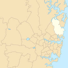
 Location of Warringah Council, 1992–2016 | |||||||||||||||
| Coordinates | 33°45′S 151°17′E / 33.750°S 151.283°E | ||||||||||||||
| Population | 140,741 (2011 census)[1] | ||||||||||||||
| • Density | 938.3/km2 (2,430/sq mi) | ||||||||||||||
| Established | 7 March 1906 | ||||||||||||||
| Abolished | 12 May 2016 | ||||||||||||||
| Area | 150 km2 (57.9 sq mi) | ||||||||||||||
| Mayor | Michael Regan | ||||||||||||||
| Council seat | Warringah Civic Centre, Dee Why | ||||||||||||||
| Region | Metropolitan Sydney | ||||||||||||||
| State electorate(s) | |||||||||||||||
| Federal division(s) | |||||||||||||||
 | |||||||||||||||
| Website | Warringah Council | ||||||||||||||
| |||||||||||||||
Warringah Council was a local government area in the northern beaches region of Sydney, in the state of New South Wales, Australia. It was proclaimed on 7 March 1906 as the Warringah Shire Council, and became "Warringah Council" in 1993. In 1992, Pittwater Council was formed when the former A Riding of Warringah Shire voted to secede. From this point on until amalgamation, Warringah Council administered 152 square kilometres (59 sq mi) of land, including nine beaches and 14 kilometres (9 mi) of coastline. Prior to its abolition it contained 6,000 hectares (15,000 acres) of natural bushland and open space, with Narrabeen Lagoon marking Warringah's northern boundary and Manly Lagoon marking the southern boundary.
On 12 May 2016 the Minister for Local Government announced that Warringah Council, along with the Pittwater and Manly councils would be merged to establish the Northern Beaches Council with immediate effect.[2] The last mayor of Warringah Council was Cr Michael Regan, who was elected on 13 September 2008. The council seat was located in Warringah Civic Centre in Dee Why on Pittwater Road.
- ^ Australian Bureau of Statistics (31 October 2012). "Warringah (A)". 2011 Census QuickStats. Retrieved 9 December 2012.
- ^ "Northern Beaches Council". Government of New South Wales. 12 May 2016. Retrieved 12 May 2016.