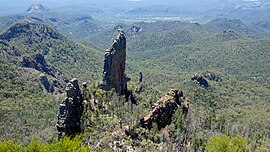
| Warrumbungle National Park New South Wales | |
|---|---|
 | |
| Nearest town or city | Coonabarabran |
| Area | 233.11 km2 (90.0 sq mi)[1] |
| Visitation | 35,000 (in 2011)[1] |
| Managing authorities | National Parks and Wildlife Service (New South Wales) |
| Website | Warrumbungle National Park |
| See also | Protected areas of New South Wales |
Warrumbungle National Park is a heritage listed national park located in the Orana region of New South Wales, Australia. The national park is located approximately 550 kilometres (340 mi) northwest of Sydney and contained within 23,311 hectares (57,600 acres). The park attracts approximately 35,000 visitors per annum.[1]
The national park is based on the geographical Warrumbungle Mountain Range, sometimes shortened to the Warrumbungles, and thus the park name is often heard in the plural. The park lies within the Pilliga Important Bird Area, so identified by BirdLife International because of its importance for a range of woodland bird species, many of which are threatened.[2]
Warrumbungle National Park was added to the Australian National Heritage List in December 2006.[3]
On 4 July 2016, the park was the first within Australia to be certified as a Dark Sky Park by the International Dark Sky Association.[4][5]
- ^ a b c "Plan of Management: Warrumbungle National Park" (PDF). NSW National Parks and Wildlife Service. Government of New South Wales: Office of Environment and Heritage. November 2012. ISBN 978-1-74293-945-2. Retrieved 26 March 2014.
- ^ "IBA: Pilliga". Birdata. Birds Australia. Retrieved 18 September 2011.
- ^ "Warrumbungle National Park". Department of the Environment, Water, Heritage and the Arts. Retrieved 18 June 2010.
- ^ "Warrumbungles Becomes Australia's First 'Dark Sky Park'". huffingtonpost.com.au.
- ^ "First Dark Sky Park in Australia Designated". darksky.org. 4 July 2016.
