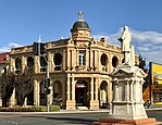
| Warwick Queensland | |||||||||||||||
|---|---|---|---|---|---|---|---|---|---|---|---|---|---|---|---|
| Coordinates | 28°12′55″S 152°02′07″E / 28.2152°S 152.0352°E | ||||||||||||||
| Population | 12,294 (2021 census)[1] | ||||||||||||||
| • Density | 416.7/km2 (1,079.4/sq mi) | ||||||||||||||
| Established | 1850 | ||||||||||||||
| Postcode(s) | 4370 | ||||||||||||||
| Elevation | 477 m (1,565 ft) | ||||||||||||||
| Area | 29.5 km2 (11.4 sq mi) | ||||||||||||||
| Location |
| ||||||||||||||
| LGA(s) | Southern Downs Region | ||||||||||||||
| County | Merivale | ||||||||||||||
| State electorate(s) | Southern Downs | ||||||||||||||
| Federal division(s) | Maranoa | ||||||||||||||
| |||||||||||||||
| |||||||||||||||
Warwick (/ˈwɒrɪk/ WORR-ik)[2] is a rural town and locality in southeast Queensland, Australia, lying 130 kilometres (81 mi) south-west of Brisbane.[3][4] It is the administrative centre of the Southern Downs Region local government area. The surrounding Darling Downs have fostered a strong agricultural industry for which Warwick, together with the larger city of Toowoomba, serve as convenient service centres. In the 2021 census, the locality of Warwick had a population of 12,294 people.[1]
- ^ a b Australian Bureau of Statistics (28 June 2022). "Warwick (SAL)". 2021 Census QuickStats. Retrieved 20 June 2024.
- ^ Macquarie Dictionary, Eighth Edition (2020). Sydney, Macmillan Publishers Australia. ISBN 1-760556-59-9
- ^ "Warwick – town (entry 36641)". Queensland Place Names. Queensland Government. Retrieved 1 October 2015.
- ^ "Warwick – locality (entry 47653)". Queensland Place Names. Queensland Government. Retrieved 1 October 2015.


