| Washford River | |
|---|---|
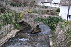
 Footbridge over the Washford River in Watchet | |
 | |
| Location | |
| Country | England within the United Kingdom |
| County | Somerset |
| Physical characteristics | |
| Source | |
| • location | Near Treborough |
| • coordinates | 51°06′34″N 3°25′12″W / 51.10943°N 3.41990°W |
| • elevation | 600 ft (180 m) |
| Mouth | Bristol Channel |
• location | Watchet |
• coordinates | 51°11′00″N 3°20′09″W / 51.18333°N 3.33583°W |
| Length | 19 kilometres (12 mi) |
| Basin size | 33.3 square kilometres (12.9 sq mi) |
The Washford River is a river in the English county of Somerset. It rises at 600 feet (183 m) above mean sea level near the village of Treborough, in the Brendon Hills, and flows into the Bristol Channel in the port town of Watchet. On its course it flows through the civil parishes of Treborough, Luxborough, Withycombe, Old Cleeve, Nettlecombe, Williton and Watchet, and through the settlements of Pooltown, Kingsbridge, Roadwater, Torre, Washford and Watchet.[1][2]
The river valley passes through the Cleeve Hill Site of Special Scientific Interest,[3] and close to Cleeve Abbey.[4]
The Washford River has a length of 19 kilometres (12 mi) and drains a catchment area of 33.3 square kilometres (12.9 sq mi). The Environment Agency defines two waterbodies for the catchment area. The Washford - Lower waterbody comprises the area up to Tacker Street, just upstream of Roadwater, whilst the Washford - Upper waterbody comprises the area above that point. As of August 2023, the Washford - Lower waterbody had a moderate ecological status, whilst the Washford - Upper had a poor ecological status. [5][6]
- ^ OS Explorer OL9: Map of Exmoor: Barnstaple, Lynton, Minehead & Dulverton (Map). Ordnance Survey. 2017. ISBN 9780319242483.
- ^ Election Maps (Map). Ordnance Survey. Retrieved 12 August 2024.
- ^ "Cleeve Hill" (PDF). English Nature. Retrieved 9 September 2006.
- ^ Historic England. "Cleeve Abbey (1014824)". National Heritage List for England. Retrieved 11 May 2013.
- ^ "Washford - Lower". Environment Agency. Retrieved 12 August 2024.
- ^ "Washford - Upper". Environment Agency. Retrieved 12 August 2024.