Washington County | |
|---|---|
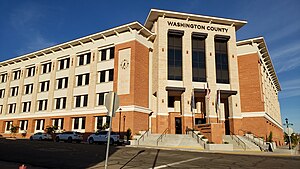
 Washington County administration building, November 2023 | |
 Location within the U.S. state of Utah | |
 Utah's location within the U.S. | |
| Coordinates: 37°17′N 113°31′W / 37.28°N 113.52°W | |
| Country | |
| State | |
| Founded | March 3, 1852 |
| Named for | George Washington |
| Seat | St. George |
| Largest city | St. George |
| Area | |
• Total | 2,430 sq mi (6,300 km2) |
| • Land | 2,426 sq mi (6,280 km2) |
| • Water | 3.6 sq mi (9 km2) 0.1% |
| Population (2020) | |
• Total | 180,279 |
• Estimate (2023)[1] | 202,452 |
| • Density | 74/sq mi (29/km2) |
| Time zone | UTC−7 (Mountain) |
| • Summer (DST) | UTC−6 (MDT) |
| Congressional district | 2nd |
| Website | www |


Washington County is a county in the southwestern corner of Utah, United States.[2] As of the 2020 United States Census, the population was 180,279,[3] making it the fifth-most populous county in Utah. Its county seat and largest city is St. George.[2][4] The county was created in 1852 and organized in 1856.[2][5] It was named after the first President of the United States, George Washington.[2] A portion of the Paiute Indian Reservation is in western Washington County. Washington County comprises the St. George, UT Metropolitan Statistical Area.[2]
- ^ "Annual Estimates of the Resident Population for Counties: April 1, 2020 to July 1, 2023". United States Census Bureau. Retrieved March 24, 2024.
- ^ a b c d e "Washington County". Washington County History Wiki. July 20, 2023. Retrieved July 20, 2023.
- ^ "State & County QuickFacts". United States Census Bureau. Retrieved October 25, 2021.
- ^ "Find a County". National Association of Counties. Retrieved June 7, 2011.
- ^ "Utah: Individual County Chronologies". Utah Atlas of Historical County Boundaries. Newberry Library. 2008. Archived from the original on March 6, 2016. Retrieved June 26, 2015.