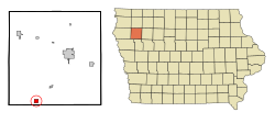
Washta, Iowa | |
|---|---|
 Location of Washta, Iowa | |
| Coordinates: 42°34′33″N 95°43′5″W / 42.57583°N 95.71806°W | |
| Country | |
| State | |
| County | Cherokee |
| Area | |
| • Total | 1.01 sq mi (2.62 km2) |
| • Land | 1.01 sq mi (2.62 km2) |
| • Water | 0.00 sq mi (0.00 km2) |
| Elevation | 1,148 ft (350 m) |
| Population (2020) | |
| • Total | 209 |
| • Density | 206.93/sq mi (79.86/km2) |
| Time zone | UTC-6 (Central (CST)) |
| • Summer (DST) | UTC-5 (CDT) |
| ZIP code | 51061 |
| Area code | 712 |
| FIPS code | 19-82380 |
| GNIS feature ID | 0462723 |
Washta is a city in Cherokee County, Iowa, United States. The population was 209 at the time of the 2020 census.[2] It is called "The Coldest Spot in Iowa", recording a temperature of −47 °F (−44 °C) without wind chill on January 12, 1912.
Washta's name dates back to 1868 when a local man named Whisman turned his farm into a trading post/mail stop for the freight train going from Correctionville, Iowa, to Cherokee, Iowa. He was asked to be the official postmaster for the area. When asked what the name of his town would be, he recalled an interesting encounter with two Native Americans the year before: While Whisman was out hunting, the two came upon him, removed his gun, looked at it, and handed it back while saying, Wash-tay, Wash-tay, meaning "good". Changing the pronunciation slightly, Whisman decided he would call the town Washta.[3]
- ^ "2020 U.S. Gazetteer Files". United States Census Bureau. Retrieved March 16, 2022.
- ^ "2020 Census State Redistricting Data". census.gov. United states Census Bureau. Retrieved August 12, 2021.
- ^ "Cherokee County, IA".