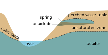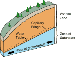

The water table is the upper surface of the zone of saturation. The zone of saturation is where the pores and fractures of the ground are saturated with groundwater,[1] which may be fresh, saline, or brackish, depending on the locality. It can also be simply explained as the depth below which the ground is saturated.
The water table is the surface where the water pressure head is equal to the atmospheric pressure (where gauge pressure = 0). It may be visualized as the "surface" of the subsurface materials that are saturated with groundwater in a given vicinity.[2]
The groundwater may be from precipitation or from groundwater flowing into the aquifer. In areas with sufficient precipitation, water infiltrates through pore spaces in the soil, passing through the unsaturated zone. At increasing depths, water fills in more of the pore spaces in the soils, until a zone of saturation is reached. Below the water table, in the phreatic zone (zone of saturation), layers of permeable rock that yield groundwater are called aquifers. In less permeable soils, such as tight bedrock formations and historic lakebed deposits, the water table may be more difficult to define.
“Water table” and “water level” are not synonymous. If a deeper aquifer has a lower permeable unit that confines the upward flow, then the water level in this aquifer may rise to a level that is greater or less than the elevation of the actual water table. The elevation of the water in this deeper well is dependent upon the pressure in the deeper aquifer and is referred to as the potentiometric surface, not the water table.[2]
- ^ "What is the Water Table?". imnh.isu.edu. Retrieved 2016-11-25.
- ^ a b Freeze, R. Allan; Cherry, John A. (1979). Groundwater. Englewood Cliffs, NJ: Prentice-Hall. ISBN 9780133653120. OCLC 252025686.[page needed]