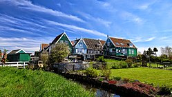
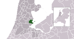
Waterland | |
|---|---|
 Marken, municipality of Waterland | |
 Location in North Holland | |
| Coordinates: 52°27′N 5°2′E / 52.450°N 5.033°E | |
| Country | Netherlands |
| Province | North Holland |
| Established | 1 January 1991 |
| Government | |
| • Body | Municipal council |
| • Mayor | Marian van der Weele (D66) |
| Area | |
• Total | 115.66 km2 (44.66 sq mi) |
| • Land | 52.11 km2 (20.12 sq mi) |
| • Water | 63.55 km2 (24.54 sq mi) |
| Elevation | −1 m (−3 ft) |
| Population (January 2021)[4] | |
• Total | 17,312 |
| • Density | 332/km2 (860/sq mi) |
| Demonym | Waterlander |
| Time zone | UTC+1 (CET) |
| • Summer (DST) | UTC+2 (CEST) |
| Postcode | 1140–1156, 1452–1454 |
| Area code | 0299 |
| Website | www |
Waterland (Dutch pronunciation: [ˈʋaːtərlɑnt] ) is a municipality in the Netherlands, in the province of North Holland. It is situated north of Amsterdam, on the western shore of the Markermeer. It includes the tourist towns of Broek in Waterland and Marken.
- ^ "Marian van der Weele nieuwe burgemeester van Waterland" (in Dutch). noord-holland.nl. Archived from the original on 19 April 2021. Retrieved 28 June 2024.
- ^ "Kerncijfers wijken en buurten 2020" [Key figures for neighbourhoods 2020]. StatLine (in Dutch). CBS. 24 July 2020. Retrieved 19 September 2020.
- ^ "Postcodetool for 1141GV". Actueel Hoogtebestand Nederland (in Dutch). Het Waterschapshuis. Retrieved 23 March 2014.
- ^ "Bevolkingsontwikkeling; regio per maand" [Population growth; regions per month]. CBS Statline (in Dutch). CBS. 1 January 2021. Retrieved 2 January 2022.

