| Waterton Lake | |
|---|---|
 Seen from Goat Haunt | |
 Waterton Lake  Waterton Lake | |
| Location | Waterton Lakes National Park, Alberta, Canada / Glacier National Park, Glacier County, Montana, United States |
| Coordinates | 49°00′00″N 113°54′00″W / 49.00000°N 113.90000°W |
| Primary outflows | Waterton River |
| Basin countries | United States, Canada |
| Surface area | 10.1 km2 (3.9 sq mi) +1.5 km2 (0.58 sq mi) |
| Average depth | 80 m (260 ft) |
| Max. depth | 150 m (490 ft) |
| Surface elevation | 1,280 m (4,200 ft) |
Waterton Lake (Paahtómahksikimi) is a mountain lake in southern Alberta, Canada, and northern Montana, United States. The lake is composed of two bodies of water, connected by a shallow channel known locally as the Bosporus.[1] The two parts are referred to as Middle Waterton Lake, and Upper Waterton Lake, the latter of which is divided by the Canada–United States border with Canada containing about two thirds of the lake while the southern third falls in the United States.[1] The Boundary Commission Trail ends at the lake as the last border marker was placed there on 8 August 1874.[2] The United States Geological Survey gives the geocoordinates of 49°03′00″N 113°54′03″W / 49.05000°N 113.90083°W for Upper Waterton Lake. Lower Waterton Lake is north of Middle Waterton Lake and is separated by a channel known as the Dardanelles.[1]
The northern, lower end of the main lake lies in Waterton Lakes National Park while the upper, southern part of the lake is located in Glacier National Park. In 1979, UNESCO established the Waterton Biosphere Reserve to protect the diverse habitats including prairie grasslands, aspen parkland, subalpine forests, alpine tundra and freshwater fens that surround the lake.[3]
Waterton-Glacier International Peace Park was created by the US and Canada in 1932, and in 1976 it was designated an International Biosphere Reserve.[4] Later, in 1995, it was inscribed as a World Heritage Site by UNESCO.[5]
The upper and middle Waterton Lake system has a surface of 10.1 km2 (3.9 sq mi), while the lower lake, which is in Canada only, has 1.5 km2 (0.58 sq mi) and lies at an altitude of 1,274 m (4,180 ft). Two soundings of the lake were 210 feet (64 m) and 317 feet (97 m), done in 1910. More recent soundings have revealed a depth of 490 ft (150 m).[6]
Highway 5 has its westernmost point on the shores of the lake.
-
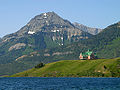 Upper Waterton Lake with Prince of Wales Hotel and Mount Richards
 -
 Waterton Lake in winter
 -
 49th parallel north at Waterton Lake
 -
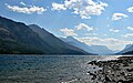 Looking south across Waterton Lake.


- ^ a b c Department of Energy, Mines and Resources Canada (1973). "Map- Waterton Lakes National Park (1973)" (PDF). GEOSCAN Canada. MCR Series no. MCR 0211.
- ^ "The Encyclopedia of Saskatchewan | Details".
- ^ UNESCO - Waterton Biosphere Reserve
- ^ U.S. Geological Survey Geographic Names Information System: Waterton-Glacier International Peace Park
- ^ UNESCO World Heritage Site - Waterton Glacier International Peace Park
- ^ "Glacier NP: Some Lakes of Glacier National Park". Archived from the original on 2008-12-21.