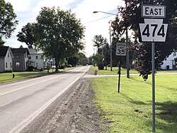
Wattsburg, Pennsylvania | |
|---|---|
 PA 474 (Jamestown Street) in Wattsburg | |
 Location in Erie County and the U.S. state of Pennsylvania. | |
| Coordinates: 42°0′10″N 79°48′34″W / 42.00278°N 79.80944°W | |
| Country | United States |
| State | Pennsylvania |
| County | Erie |
| Area | |
| • Total | 0.31 sq mi (0.80 km2) |
| • Land | 0.30 sq mi (0.77 km2) |
| • Water | 0.01 sq mi (0.03 km2) |
| Elevation [2] (Borough benchmark) | 1,286 ft (392 m) |
| Highest elevation [2] (northeast end of borough) | 1,300 ft (400 m) |
| Lowest elevation | 1,278 ft (390 m) |
| Population | |
| • Total | 353 |
| • Density | 1,184.56/sq mi (457.90/km2) |
| Time zone | UTC-4 (EST) |
| • Summer (DST) | UTC-5 (EDT) |
| ZIP code | 16442 |
| Area code | 814 |
Wattsburg is a borough in Erie County, Pennsylvania, United States. The population was 352 at the 2020 census.[4] It is part of the Erie Metropolitan Statistical Area.
- ^ "ArcGIS REST Services Directory". United States Census Bureau. Retrieved October 16, 2022.
- ^ a b c "Little Hope Topo Map, Erie County PA (Wattsburg Area)". TopoZone. Locality, LLC. Retrieved 2 September 2019.
- ^ "Census Population API". United States Census Bureau. Retrieved Oct 12, 2022.
- ^ Bureau, US Census. "City and Town Population Totals: 2020—2021". Census.gov. US Census Bureau. Retrieved July 24, 2022.
{{cite web}}:|last1=has generic name (help)