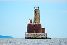
 Waugoshance in 2015 | |
 | |
| Location | Lake Michigan |
|---|---|
| Coordinates | 45°47′10″N 85°5′28″W / 45.78611°N 85.09111°W |
| Tower | |
| Constructed | 1850 |
| Foundation | Timber crib filled with stone/concrete |
| Construction | Brick encased with steel or iron boilerplate[5][6] |
| Height | 63 feet (19 m)[2][3] |
| Shape | Frustum of a cone (encased in iron in 1883) |
| Markings | Natural |
| Heritage | National Register of Historic Places listed place |
| Fog signal | Original: Fog bell, Steam Whistle |
| Light | |
| First lit | 1851 |
| Deactivated | 1912[1] |
| Focal height | 74 feet (23 m)[4] |
| Lens | Fourth order Fresnel lens[7] |
Waugoshance Light Station | |
| Nearest city | Waugoshance Island, Michigan |
| Area | 0.1 acres (0.040 ha) |
| MPS | U.S. Coast Guard Lighthouses and Light Stations on the Great Lakes TR |
| NRHP reference No. | 83000841[8] |
| Added to NRHP | August 04, 1983 |
The ruined lighthouse at Waugoshance protects boats from a shoal area at the northern end of Lake Michigan. The lighthouse is located in Emmet County, Michigan, United States, and in U.S. Coast Guard District No. 9.[9][10] It is approximately 15 miles (24 km) west of Mackinaw City. Due to erosion and deterioration, the lighthouse is deteriorating and critically endangered, and likely to fall into the lake in the near future.[11]
- ^ Lighthouse Central, Photographs, History, Directions and Way points for Waugoshance Light, The Ultimate Guide to West Michigan Lighthouses by Jerry Roach (Publisher: Bugs Publishing LLC - 2005). ISBN 0-9747977-0-7. Archived August 27, 2009, at the Wayback Machine
- ^ Pepper, Terry. "Database of Tower Heights". Seeing the Light. terrypepper.com.
- ^ "Michigan Lighthouse Conservancy, Waugoshance Light".
- ^ Pepper, Terry. "Database of Focal Heights". Seeing the Light. terrypepper.com.
- ^ However, other sources say it is "iron"boiler plate. See Michigan Lighthouse Project, Waugoshance Light.
- ^ "Detroit News, Interactive map on Michigan lighthouses". Detroit News.
- ^ Pepper, Terry. "Database of Original Lenses". Seeing the Light. terrypepper.com.
- ^ "National Register Information System". National Register of Historic Places. National Park Service. March 13, 2009.
- ^ "Amateur Radio Lighthouse Society, USA-784, Waugoshance Light (Lake Michigan)".
- ^ "Michigan Lighthouse conservancy, Waugoshance Light".
- ^ Carlisle, John (March 14, 2021). "Up North Lighthouse likely to fall into Lake Michigan: After a century of neglect 'It's going pretty quick'". Detroit Free Press. pp. 1A, 8A–9A.