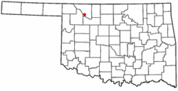
Waynoka, Oklahoma | |
|---|---|
 Location of Waynoka, Oklahoma | |
| Coordinates: 36°34′56″N 98°52′47″W / 36.58222°N 98.87972°W | |
| Country | United States |
| State | Oklahoma |
| County | Woods |
| Area | |
| • Total | 1.00 sq mi (2.60 km2) |
| • Land | 1.00 sq mi (2.60 km2) |
| • Water | 0.00 sq mi (0.00 km2) |
| Elevation | 1,493 ft (455 m) |
| Population (2020) | |
| • Total | 708 |
| • Density | 705.18/sq mi (272.37/km2) |
| Time zone | UTC-6 (Central (CST)) |
| • Summer (DST) | UTC-5 (CDT) |
| ZIP code | 73860 |
| Area code | 580 |
| FIPS code | 40-79350[3] |
| GNIS feature ID | 1099446[2] |
Waynoka is a city in Woods County, Oklahoma, United States. It is located on U.S. Highway 281 and State Highway 14, seventy miles west of Enid. The population, which peaked at 2,018 in 1950, was 708 at the time of the 2020 Census.[4]
- ^ "ArcGIS REST Services Directory". United States Census Bureau. Retrieved September 20, 2022.
- ^ a b U.S. Geological Survey Geographic Names Information System: Waynoka, Oklahoma
- ^ "U.S. Census website". United States Census Bureau. Retrieved January 31, 2008.
- ^ "Waynoka (city), Oklahoma". United States Census Bureau. Retrieved April 20, 2024.