This article needs additional citations for verification. (August 2009) |
| Wda | |
|---|---|
 | |
 | |
| Location | |
| Country | Poland |
| Physical characteristics | |
| Mouth | |
• location | Vistula |
• coordinates | 53°24′42″N 18°28′45″E / 53.4117°N 18.4792°E |
| Length | 198 km (123 mi) |
| Basin size | 2,325 km2 (898 sq mi) |
| Discharge | |
| • average | 6.52 m3/s (230 cu ft/s) |
| Basin features | |
| Progression | Vistula→ Baltic Sea |
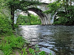
The Wda (German: Schwarzwasser) is a river in Poland; it has a lowland character. The Wda is one of the 15 main canoe trails in Poland. It is 198 km long and the surface of its catchment area amounts to 2325 km2. The Wda's average gradient is 0.7‰ and its flow is 6.52 m3/s.
The Wda begins its course at Krążno Lake and ends in the Wisła in Świecie. The Wda is one of the longest rivers in Bory Tucholskie and one of the most important of Pomorze's river routes.