Welland | |
|---|---|
| City of Welland | |
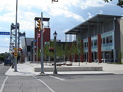
 The Welland Civic Square | |
| Nickname: The Rose City | |
| Motto(s): Where Rails and Water Meet | |
 Location of Welland in the Niagara Region | |
| Coordinates: 42°59′N 79°14′W / 42.983°N 79.233°W | |
| Country | Canada |
| Province | Ontario |
| Region | Niagara |
| Settled | 1788 |
| Incorporated (village) | 1858 |
| Incorporated (city) | 1917 |
| Government | |
| • Mayor | Frank Campion |
| • Governing body | Welland City Council |
| • MP | Vance Badawey |
| • MPP | Jeff Burch |
| Area | |
| • Land | 81.04 km2 (31.29 sq mi) |
| Elevation | 175.30 m (575.13 ft) |
| Population (2021)[1] | |
| • Total | 55,750 |
| • Density | 645.3/km2 (1,671/sq mi) |
| Time zone | UTC−5 (Eastern (EST)) |
| • Summer (DST) | UTC−4 (EDT) |
| Forward Sortation Area | |
| Area code | 905 / 289 / 365 / 742 |
| Highways | |
| Website | welland |
Welland is a city in the Regional Municipality of Niagara in Southern Ontario, Canada. As of 2021, it had a population of 55,750.[1]
The city is in the centre of Niagara and located within a half-hour driving distance to Niagara Falls, Niagara-on-the-Lake, St. Catharines, and Port Colborne. It has been traditionally known as the place where rails and water meet, referring to the railways from Buffalo to Toronto and Southwestern Ontario, and the waterways of Welland Canal and Welland River, which played a great role in the city's development. The city has developed on both sides of the Welland River and Welland Canal, which connect Lake Erie and Lake Ontario.
- ^ a b c "Welland, Ontario census profile". 2016 Census of Population. Statistics Canada. Retrieved 5 March 2015.
- ^ Cite error: The named reference
envcanwas invoked but never defined (see the help page).

