| Wells Gray-Clearwater volcanic field | |
|---|---|
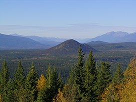
 A view from Green Mountain with Pyramid Mountain in the distance | |
| Highest point | |
| Elevation | 2,100 m (6,900 ft) |
| Coordinates | 52°20′N 120°34′W / 52.33°N 120.57°W |
| Geography | |
 | |
| Location | British Columbia, Canada |
| Parent range | Quesnel Highland/Shuswap Highland/Cariboo Mountains |
| Geology | |
| Rock age | Pliocene-to-Holocene |
| Mountain type | Monogenetic volcanic field |
| Last eruption | 1550 (?)[1] |
The Wells Gray-Clearwater volcanic field, also called the Clearwater Cone Group,[2] is a potentially active[3] monogenetic volcanic field in east-central British Columbia, Canada, located approximately 130 km (81 mi) north of Kamloops. It is situated in the Cariboo Mountains of the Columbia Mountains and on the Quesnel and Shuswap Highlands. As a monogenetic volcanic field, it is a place with numerous small basaltic volcanoes and extensive lava flows.[4][5]
Most of the Wells Gray-Clearwater volcanic field is encompassed within a large wilderness park called Wells Gray Provincial Park.[4] This 5,405 km2 (2,087 sq mi) park was established in 1939 to protect Helmcken Falls and the unique features of the Clearwater River drainage basin, including this volcanic field.[4] Five roads enter the park and provide views of some of the field's volcanic features.[4] Short hikes lead to several other volcanic features, but some areas are accessible only by aircraft.[6]
- ^ Cite error: The named reference
JKwas invoked but never defined (see the help page). - ^ Cite error: The named reference
JIwas invoked but never defined (see the help page). - ^ Etkin, David; Haque, C.E.; Brooks, Gregory R. (2003-04-30). An Assessment of Natural Hazards and Disasters in Canada. Springer. p. 569. ISBN 978-1-4020-1179-5.
- ^ a b c d "Wells Gray – Clearwater volcano field". Catalogue of Canadian volcanoes. Geological Survey of Canada. 2008-02-13. Archived from the original on 2006-10-08. Retrieved 2008-08-14.
- ^ "Volcanic Fields and Lava Fields, Monogenetic Volcanic Fields – Mafic Volcanoes". United States Geological Survey. Retrieved 2008-08-14.
- ^ Wood, Charles A.; Kienle, Jürgen (1990). Volcanoes of North America: United States and Canada. Cambridge, England: Cambridge University Press. ISBN 0-521-43811-X.