| J.W. Wells State Park | |
|---|---|
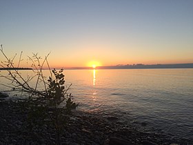
 Sunset at Wells State Park | |
| Location | Cedarville Township, Menominee County, Michigan, United States |
| Nearest city | Menominee, Michigan |
| Coordinates | 45°24′06″N 87°22′19″W / 45.40167°N 87.37194°W[2] |
| Area | 678 acres (274 ha) |
| Elevation | 591 feet (180 m) [2] |
| Designation | Michigan state park |
| Established | 1925[3] |
| Administrator | Michigan Department of Natural Resources |
| Website | Wells State Park |
J. W. Wells State Park | |
| Built | 1927 |
| NRHP reference No. | 02000040 |
| Added to NRHP | February 25, 2002 |
J.W. Wells State Park (also known as Wells State Park) is a state park in the U.S. state of Michigan. The 678-acre (2.74 km2) park is located in Menominee County on the shore of Lake Michigan's Green Bay, just south of Cedar River.[4] It is on M-35, roughly midway between Menominee and Escanaba. It was added to the National Register of Historic Places in 2002.[5]
- ^ "Wells State Park". IUCN. Retrieved April 22, 2020.
- ^ a b "J W Wells State Park". Geographic Names Information System. United States Geological Survey, United States Department of the Interior.
- ^ Cite error: The named reference
mdnr3was invoked but never defined (see the help page). - ^ Cite error: The named reference
mdnrwas invoked but never defined (see the help page). - ^ Cite error: The named reference
npswas invoked but never defined (see the help page).

