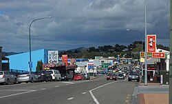
Wellsford
Whakapirau (Māori) | |
|---|---|
 Main Street in Wellsford | |
 | |
| Coordinates: 36°17′45″S 174°31′24″E / 36.29583°S 174.52333°E | |
| Country | New Zealand |
| Region | Auckland |
| Ward | Rodney ward |
| Community board | Rodney Local Board |
| Subdivision | Wellsford subdivision |
| Electorates | |
| Government | |
| • Territorial Authority | Auckland Council |
| Area | |
| • Total | 4.72 km2 (1.82 sq mi) |
| Population (June 2024)[2] | |
| • Total | 2,240 |
| • Density | 470/km2 (1,200/sq mi) |
| Postcode(s) | 0900, 0977, 0975, 0972, 0974, 0973 |
Wellsford (Māori: Whakapirau)[3] is a town on the Northland Peninsula in the northern North Island of New Zealand. It is the northernmost major settlement in the Auckland Region, and is 77 kilometres (48 mi) northwest of the Auckland CBD. It is a major regional centre, being located at the junction of State Highways 1 and 16, almost halfway between Auckland and the Northland city of Whangārei.
The eastern Kaipara Harbour has been settled by Māori since the 13th or 14th centuries, who utilised the inland forests and marine resources of the Kaipara Harbour. The area became home to the Ngāti Whātua collective Te Uri-o-Hau by the mid-17th century, with hapū including Ngāti Mauku, Ngāti Tahuhu and Ngāti Rongo being established from the descendants of Haumoewhārangi, and by strategic marriages with Te Kawerau hapū.
Wellsford was established by the Albertlanders in 1862, a group of Baptist tradespeople and farmers from the Birmingham area who settled the southern Oruawharo River, developing into a timber and kauri gum. By the early 20th century, the area developed into a regional centre for dairy farming, in part due to the opening of Wellsford railway station in 1909, linking the town to Auckland.
- ^ Cite error: The named reference
Areawas invoked but never defined (see the help page). - ^ "Aotearoa Data Explorer". Statistics New Zealand. Retrieved 26 October 2024.
- ^ Rodney Local Board (May 2023). Wellsford Centennial Park Masterplan (PDF) (Report). Auckland Council. Retrieved 16 January 2024.