Wellsville, Utah | |
|---|---|
 The Wellsville Tabernacle, an early Latter-day Saint meetinghouse | |
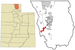
 Location in Cache County and the state of Utah | |
| Coordinates: 41°38′8″N 111°55′59″W / 41.63556°N 111.93306°W | |
| Country | United States |
| State | Utah |
| County | Cache |
| Founded (as Maughan's Fort) | 1856 |
| Named for | Daniel H. Wells |
| Area | |
| • Total | 7.28 sq mi (18.86 km2) |
| • Land | 7.27 sq mi (18.83 km2) |
| • Water | 0.01 sq mi (0.04 km2) |
| Elevation | 4,547 ft (1,386 m) |
| Population (2020) | |
| • Total | 4,060 |
| • Density | 542.17/sq mi (209.32/km2) |
| Time zone | UTC-7 (Mountain (MST)) |
| • Summer (DST) | UTC-6 (MDT) |
| ZIP code | 84339 |
| Area code | 435 |
| FIPS code | 49-82620[3] |
| GNIS feature ID | 1447103[2] |
| Website | www |
Wellsville is a city in Cache County, Utah, United States. The population was 4,060 at the 2020 census.[4] Wellsville is located at the base of the Wellsville mountain range. It is included in the Logan, Utah-Idaho Metropolitan Statistical Area.
Wellsville is home to the Utah State University South Farm as well as the Utah State University Equestrian Center, the American Heritage Center and the Wellsville Tabernacle.
Wellsville was laid out in 1856, and named after Daniel H. Wells, a Mormon leader.[5]
- ^ "2019 U.S. Gazetteer Files". United States Census Bureau. Retrieved August 7, 2020.
- ^ a b U.S. Geological Survey Geographic Names Information System: Wellsville
- ^ "U.S. Census website". United States Census Bureau. Retrieved January 31, 2008.
- ^ "USA Today, 2020 Census Data -- Wellsville, Ut". Retrieved April 14, 2024.
- ^ Lund, Anthon Henrik (1922). The Utah Genealogical and Historical Magazine. Geneal. Society of Utah. p. 41.