Welshpool Road Welshpool Road East | |||
|---|---|---|---|
 | |||
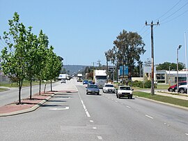
| View east along Welshpool Road in Welshpool | |||
 | |||
| General information | |||
| Type | Road | ||
| Length | 15 km (9.3 mi) | ||
| Route number(s) | |||
| Former route number | |||
| Major junctions | |||
| |||
| West end | |||
| |||
| East end | William Street, Welshpool | ||
| |||
| West end | |||
| |||
| East end | |||
| Location(s) | |||
| Major suburbs | Queens Park, Wattle Grove, Lesmurdie | ||
| ---- | |||
Welshpool Road is a major arterial road running through the metropolitan area of Perth, Western Australia. Although the road is now split in two, having had its western and eastern sections disconnected due to the extension of Roe Highway, it remains Welshpool's second most important road (after Orrong Road), and the highest quality access road for the Darling Scarp.
Welshpool Road East is part of State Route 8,[1] while the entire road was previously allocated State Route 35.[2]
- ^ Distance book (12 ed.). Main Roads Western Australia. 2012. pp. 4–5. ISBN 978-0-7309-7657-8. Retrieved 3 January 2014.
- ^ "Route Numbering System" (PDF). Main Roads Western Australia. Archived from the original (PDF) on 27 July 2008. Retrieved 3 January 2014.